Category:Maps of Hachinohe
Subcategories
This category has only the following subcategory.
Media in category "Maps of Hachinohe"
The following 23 files are in this category, out of 23 total.
-
 Aomori-hachinohe-city.svg 779 × 755; 16 KB
-
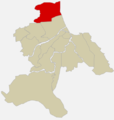
 Hachinohe in Aomori Prefecture.png 1,081 × 801; 38 KB
-
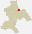
 JP Aomori Hachinohe City Location.png 1,495 × 1,060; 49 KB
-
 Hachinohe in Aomori Prefecture Ja.svg 800 × 770; 29 KB
-
 Aomori Hachinohe.png 328 × 241; 5 KB
-
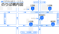 Hachinohe-centertarminal-map.png 1,422 × 829; 85 KB
-
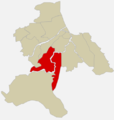
 Hachinohesynoecismmap01.png 473 × 497; 55 KB
-
 Hachinohesynoecismmap02.png 473 × 497; 65 KB
-
 Hachinohetown.png 473 × 497; 149 KB
-
 Ichikawavil.png 473 × 497; 149 KB
-
 Kaminaganawashirovil.png 473 × 497; 150 KB
-
 Konakanotown.png 473 × 497; 149 KB
-
 Korekawavil.png 473 × 497; 150 KB
-
 Minatotown.png 473 × 497; 150 KB
-
 Nangovil.png 473 × 497; 150 KB
-
 Odatevil.png 473 × 497; 149 KB
-
 Piado-busmap.png 1,340 × 1,083; 99 KB
-
 Samevil.png 473 × 497; 150 KB
-
 Shadow picture of Hachinohe city.svg 499 × 567; 261 KB
-
 Shimonaganawashirovil.png 473 × 497; 150 KB
-
 Tatevil.png 473 × 497; 150 KB
-
 Toyosakivil.png 473 × 497; 149 KB
-
 地図-青森県八戸市-2006.png 389 × 260; 7 KB


