Category:Maps of Hampshire County, Massachusetts
Counties of Massachusetts: Barnstable · Berkshire · Bristol · Dukes · Essex · Franklin · Hampden · Hampshire · Middlesex · Nantucket · Norfolk · Plymouth · Suffolk · Worcester
Wikimedia category | |||||
| Upload media | |||||
| Instance of | |||||
|---|---|---|---|---|---|
| Category combines topics | |||||
| Hampshire County | |||||
county in Massachusetts, United States    | |||||
| Instance of | |||||
| Named after | |||||
| Location | Massachusetts | ||||
| Capital | |||||
| Inception |
| ||||
| Population |
| ||||
| Area |
| ||||
| Different from | |||||
| official website | |||||
 | |||||
Subcategories
This category has the following 9 subcategories, out of 9 total.
A
B
N
S
W
Media in category "Maps of Hampshire County, Massachusetts"
The following 18 files are in this category, out of 18 total.
-
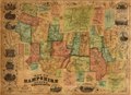
 1854 map HampshireCounty Massachusetts byBarker BPL 12700.png 988 × 710; 1.23 MB
-

-
-
 A topographical map of Hampshire County Massachusetts (2674823757).jpg 2,000 × 1,362; 2.2 MB
-
 Geological map of South Hadley.jpg 2,651 × 3,084; 2.13 MB
-
 Hampshire and Hamden Counties.jpg 1,024 × 626; 122 KB
-
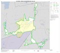
 Hampshire County, Massachusetts LOC 81690019.jpg 7,217 × 5,048; 4.24 MB
-
 Hampshire County, Massachusetts LOC 81690019.tif 7,217 × 5,048; 104.23 MB
-
 Ma01 109.gif 634 × 379; 29 KB
-
 Ma02 109.gif 636 × 379; 28 KB
-
 Map of Hampshire County, Massachusetts (3120846060).jpg 2,000 × 1,492; 3.33 MB
-
 Map of Hampshire County, Massachusetts LOC 2008624301.jpg 16,339 × 11,866; 30.18 MB
-
 Map of Hampshire County, Massachusetts LOC 2008624301.tif 16,339 × 11,866; 554.69 MB
-
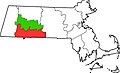
 Map of Massachusetts highlighting Hampshire County.svg 2,976 × 1,819; 43 KB
-
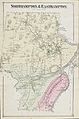
 Map of the county of Hampshire, Massachusetts (2674366559).jpg 1,959 × 2,000; 3.59 MB
-
 Massachusetts location Hampshire.svg 500 × 314; 176 KB
-
 Northampton Easthampton SmithsFerry Map.jpg 4,560 × 6,889; 10.58 MB
-
 Springfield, MA Metropolitan Area.png 392 × 261; 13 KB


.jpg)


.jpg)

.jpg)


