Category:Maps of Howrah district
Districts of West Bengal: Alipurduar · Bankura · Birbhum · Cooch Behar · Dakshin Dinajpur · Darjeeling · Hooghly · Howrah · Jalpaiguri · Jhargram · Kalimpong · Kolkata · Malda · Murshidabad · Nadia · North 24 Parganas · Paschim Bardhaman · Paschim Medinipur · Purba Bardhaman · Purba Medinipur · Purulia · South 24 Parganas · Uttar Dinajpur
Subcategories
This category has the following 2 subcategories, out of 2 total.
Media in category "Maps of Howrah district"
The following 11 files are in this category, out of 11 total.
-
 Bhurshut.JPG 393 × 600; 36 KB
-
 Howrah district.png 287 × 441; 38 KB
-
 Howrah in West Bengal (India).svg 1,039 × 1,585; 850 KB
-
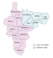 Howrah Subdivision Map (bn).svg 512 × 552; 129 KB
-
 Howrah Subdivision Map (en).svg 512 × 552; 87 KB
-
 Howrah Tehsil Map (bn).svg 512 × 552; 112 KB
-
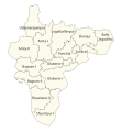 Howrah Tehsil Map (en).svg 512 × 552; 82 KB
-
 Kalyanpur Karte.JPG 1,101 × 1,252; 311 KB
-
 Map of Howrah district .svg 1,050 × 1,200; 185 KB
-
 Map of Uluberia Subdivision showing the Administrative Units.jpg 724 × 1,024; 261 KB
-
 হাওড়া জেলা.svg 1,136 × 1,210; 140 KB


.svg)
.svg)
.svg)
.svg)
.svg)


