Category:Maps of Jewish Medieval history
Subcategories
This category has the following 4 subcategories, out of 4 total.
M
- Maps of the Eighth Crusade (3 F)
- Maps of the Ninth Crusade (8 F)
- Maps of the Second Crusade (8 F)
- Maps of the Seventh Crusade (5 F)
Media in category "Maps of Jewish Medieval history"
The following 23 files are in this category, out of 23 total.
-
 Argasoù ar yuzevien.jpg 1,156 × 654; 168 KB
-
 Ayyubid Dynasty 1171 - 1246(AD).PNG 821 × 440; 37 KB
-
 Bney hes bney khes in 15th century.svg 663 × 350; 991 KB
-
 Conquête de l'Islam à la chute des Omeyyades he.svg 1,304 × 614; 660 KB
-
 Crusader castels heb.jpg 288 × 559; 138 KB
-
 Ekpulsado di Judii de Europa 1100 til 1600.svg 570 × 400; 254 KB
-
 Europe in 1470 VOLTTERA.jpg 1,000 × 805; 189 KB
-
 Expulsion judios-en selection.svg 8,960 × 6,672; 318 KB
-
 Expulsion judios-en.svg 8,960 × 6,672; 326 KB
-
 Expulsion judios-fa.svg 570 × 400; 208 KB
-
 Expulsion judios-he.svg 570 × 400; 422 KB
-
 Expulsion judios-mk.svg 570 × 400; 226 KB
-
 Expulsión judíos.svg 570 × 400; 348 KB
-
 Fatimid Islamic Caliphate He.png 1,000 × 550; 115 KB
-
 Joodse verhuizing binnen Europa.svg 570 × 400; 253 KB
-
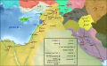
 Map Crusader states 1190-he.svg 978 × 1,330; 356 KB
-
 Mongol raids in Syria and Palestine 1260-he.svg 657 × 901; 272 KB
-
 Mongol raids into Syria and Palestine ca 1300-he.svg 657 × 901; 265 KB
-
 Morava, židovské osídlení 1300.svg 1,800 × 1,330; 41 KB
-
 Morava, židovské osídlení do 1420.svg 1,800 × 1,330; 68 KB
-
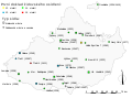
 Radhanite1.jpg 800 × 376; 58 KB
-
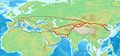
 Radhanites2.png 1,201 × 601; 1.41 MB
-
 מפת מסעות יהודה אלחריזי.svg 1,193 × 743; 4.59 MB

.PNG)


