Category:Maps of Logan County, Ohio
Wikimedia category | |||||
| Upload media | |||||
| Instance of | |||||
|---|---|---|---|---|---|
| Category combines topics | |||||
| Logan County | |||||
county in Ohio, United States     | |||||
| Instance of | |||||
| Named after | |||||
| Location | Ohio | ||||
| Capital | |||||
| Inception |
| ||||
| Population |
| ||||
| Area |
| ||||
| Different from | |||||
| official website | |||||
 | |||||
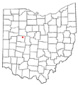
Logan County is in northwest Ohio in the United States. Its county seat is Bellefontaine.
Subcategories
This category has the following 5 subcategories, out of 5 total.
Media in category "Maps of Logan County, Ohio"
The following 47 files are in this category, out of 47 total.
-
 Detailed map of De Graff, Ohio.png 575 × 425; 32 KB
-
 Detailed map of Huntsville, Ohio.png 575 × 425; 17 KB
-
 Detailed map of Lakeview, Ohio.png 575 × 425; 21 KB
-
 Detailed map of Quincy, Ohio.png 575 × 425; 16 KB
-
 Detailed map of Ridgeway, Ohio.png 575 × 425; 15 KB
-
 Detailed map of Rushsylvania, Ohio.png 575 × 425; 17 KB
-
 Detailed map of Russells Point, Ohio.png 575 × 425; 28 KB
-
 Detailed map of Valley Hi, Ohio.png 575 × 425; 16 KB
-
 Detailed map of West Liberty, Ohio.png 575 × 425; 24 KB
-
 Detailed map of West Mansfield, Ohio.png 575 × 425; 17 KB
-
 Detailed map of Zanesfield.png 575 × 425; 14 KB
-
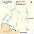 Logans Raid.png 3,083 × 3,083; 612 KB
-
 Map of Ohio highlighting Logan County.svg 3,675 × 3,995; 58 KB
-
 OHMap-doton-De Graff.png 274 × 300; 10 KB
-
 OHMap-doton-East Liberty.png 274 × 300; 14 KB
-
 OHMap-doton-Huntsville.png 274 × 300; 10 KB
-
 OHMap-doton-Lakeview.png 274 × 300; 10 KB
-
 OHMap-doton-Lewistown.png 274 × 300; 14 KB
-
 OHMap-doton-Logansville.png 309 × 352; 17 KB
-
 OHMap-doton-Middleburg.png 309 × 352; 17 KB
-
 OHMap-doton-Northwood Logan County.png 309 × 352; 17 KB
-
 OHMap-doton-Pickrelltown.png 309 × 352; 17 KB
-
 OHMap-doton-Quincy.png 274 × 300; 10 KB
-
 OHMap-doton-Ridgeway.png 274 × 300; 10 KB
-
 OHMap-doton-Rushsylvania.png 274 × 300; 10 KB
-
 OHMap-doton-Russells Point.png 274 × 300; 10 KB
-
 OHMap-doton-Santa Fe.png 274 × 300; 13 KB
-
 OHMap-doton-Valley Hi.png 274 × 300; 10 KB
-
 OHMap-doton-West Liberty.png 274 × 300; 10 KB
-
 OHMap-doton-West Mansfield.png 274 × 300; 10 KB
-
 OHMap-doton-Zanesfield.png 274 × 300; 10 KB
-
 OHmap-hilite-Bloomfield Twp Logan Co.png 274 × 300; 14 KB
-
 OHmap-hilite-Bokes Creek Twp Logan Co.png 274 × 300; 14 KB
-
 OHmap-hilite-Harrison Twp Logan Co.png 274 × 300; 14 KB
-
 OHmap-hilite-Jefferson Twp.png 274 × 300; 14 KB
-
 OHmap-hilite-Lake Twp Logan Co.png 274 × 300; 14 KB
-
 OHmap-hilite-Liberty Twp Logan Co.png 274 × 300; 14 KB
-
 OHmap-hilite-McArthur Twp Logan Co.png 274 × 300; 14 KB
-
 OHmap-hilite-Miami Twp Logan Co.png 274 × 300; 14 KB
-
 OHmap-hilite-Monroe Twp.png 274 × 300; 14 KB
-
 OHmap-hilite-Perry Twp.png 274 × 300; 14 KB
-
 OHmap-hilite-Pleasant Twp Logan Co.png 274 × 300; 14 KB
-
 OHmap-hilite-Richland Twp Logan Co.png 274 × 300; 14 KB
-
 OHmap-hilite-Rushcreek Twp Logan Co.png 274 × 300; 14 KB
-
 OHmap-hilite-Stokes Twp Logan Co.png 274 × 300; 14 KB
-
 OHmap-hilite-Union Twp Logan Co.png 274 × 300; 14 KB
-
 OHmap-hilite-Washington Twp Logan Co.png 274 × 300; 14 KB


