Category:Maps of Long Island City, Queens
Media in category "Maps of Long Island City, Queens"
The following 69 files are in this category, out of 69 total.
-

-

-

-
 2012 NY-12 election results.svg 800 × 1,012; 15 KB
-
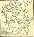
 Belcher Hyde Blissville map.jpg 755 × 559; 582 KB
-

-

-

-

-

-

-
 EB9 New York - City and vicinity.jpg 3,837 × 5,476; 4.69 MB
-
 LIRR 1891 Laurel Hill station.jpg 679 × 594; 114 KB
-
 LIRR 1891 Long Island City.jpg 2,524 × 1,536; 860 KB
-
 Long Island City map 1896.jpg 360 × 615; 296 KB
-
 Old Tracks and Routes in Newtown (Plate LIV, p. 272).jpg 1,052 × 1,628; 236 KB
-
 Old Tracks and Routes in Newtown - Crop.jpg 959 × 1,038; 413 KB
-

-

-

-

-
-

-

-

-

-

-

-

-

-
-

-

-

-

-

-

-

-

-

-

-

-

-

-

-

-

-

-
-

-

-

-

-

-

-

-

-

-

-

-

-

-
 Queensboro Plaza Weekend Service Changes Maps (53407827232).png 4,281 × 2,752; 2.09 MB
-
 Queensboro Plaza Weekend Service Changes Maps (53408749866).png 3,605 × 2,144; 2.47 MB
-
 Queensboro Plaza Weekend Service Changes Maps (53408929343).png 4,281 × 2,743; 3.09 MB
-
 Queensboro Plaza Weekend Service Changes Maps (53409084949).png 4,281 × 1,837; 2.74 MB
-

-
 Sunnyside Yard, Amtrak and MTA, NYC.png 3,007 × 1,322; 3.09 MB
-
 The New York improvement and tunnel extension of the Pennsylvania railroad.jpg 1,672 × 1,424; 384 KB


_-_Queens_County_-_Queens_-_ED_41-1_to_2176_-_NARA_-_24519584_(page_4).jpg)


_(14755089431).jpg)
_(14755160801).jpg)
_(14757960362).jpg)
_(14758024062).jpg)
_(14758045692).jpg)
_(14778146273).jpg)


.jpg)

.png)
.png)
.png)
.png)
.jpg)

