Category:Maps of Ontario Townships, circa 1880
Media in category "Maps of Ontario Townships, circa 1880"
The following 23 files are in this category, out of 23 total.
-
 Adjala Township, Simcoe County, Ontario, 1880.jpg 2,766 × 4,242; 3.21 MB
-
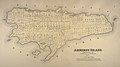 Amherst Island 1878 map.jpg 3,827 × 2,130; 2.68 MB
-
 Essa Township, Simcoe County, Ontario, 1880.jpg 3,349 × 4,121; 3.44 MB
-
 Flos Township, Simcoe County, Ontario, 1880.jpg 4,233 × 3,052; 3.29 MB
-
 Howe Island 1878 map.jpg 4,437 × 2,895; 3.84 MB
-
 Innisfil Township, Simcoe County, Ontario, 1880.jpg 3,643 × 3,439; 3.09 MB
-
 Matchedash Township, Simcoe County, Ontario, 1880.jpg 4,252 × 2,940; 3.02 MB
-
 Medonte Township, Simcoe County, Ontario, 1880.jpg 4,117 × 3,243; 3.2 MB
-
 Mulmur Township, Dufferin County, Ontario, 1880.jpg 3,764 × 3,290; 2.54 MB
-
 Nottawasaga Township, Simcoe County, Ontario, 1880.jpg 2,306 × 4,287; 2.72 MB
-
 Orillia Township, Simcoe County, Ontario, 1880.jpg 4,271 × 2,820; 3 MB
-
 Oro Township, Simcoe County, Ontario, 1880.jpg 4,230 × 3,253; 4.12 MB
-
 Sunnidale Township, Simcoe County, Ontario, 1880.jpg 2,639 × 4,298; 2.98 MB
-
 Tay Township, Simcoe County, Ontario, 1880.jpg 3,374 × 3,336; 2.6 MB
-
 Tecumseth Township, Simcoe County, Ontario, 1880.jpg 3,856 × 3,289; 2.83 MB
-
 Tiny Township, Simcoe County, Ontario, 1880.jpg 3,344 × 4,043; 2.88 MB
-
 Tosorontio Township, Simcoe County, Ontario, 1880.jpg 2,233 × 4,225; 7.82 MB
-
 Township of West Gwilliumbury, Simcoe County, Ontario, 1880.jpg 3,427 × 4,352; 5.99 MB
-
 Vespra Township, Simcoe County, Ontario, 1880.jpg 3,784 × 3,287; 3.72 MB
-
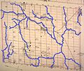
 Watercourses of Adjala Township, Simcoe County, Ontario, 1880.jpg 2,766 × 4,242; 2.53 MB
-
 Watercourses of Tecumseth Township, Simcoe County, Ontario, 1880.jpg 3,856 × 3,289; 2.8 MB
-
 Watercourses of West Gwillimbury Township, Simcoe County, Ontario, 1880.jpg 3,427 × 4,352; 4.89 MB
-
 Wolfe Island 1878 map.jpg 4,599 × 2,769; 4.95 MB


