Category:Maps of Portugal by Fernando Álvares Seco
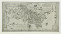
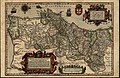
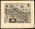
English: Fernando Álvares Seco produced a notable map of Portugal in the 1560s. It was widely published first by Abraham Ortelius in the Theatrum, then a modified version was published in the Jodocus Hondius Mercator-Hondius Atlas. See also Fernando Álvaro Seco on Portuguese Wikipedia.
Media in category "Maps of Portugal by Fernando Álvares Seco"
The following 34 files are in this category, out of 34 total.
-
 Cartouche met rolwerk en drie maskers, BI-1934-1775-22-2.jpg 1,582 × 1,300; 455 KB
-

-
 Portugalliae - que olim Lusitania, nouissima & exactissima descriptio LOC 2001622524.jpg 6,054 × 4,120; 5.6 MB
-
 Portugalliae - que olim Lusitania, nouissima & exactissima descriptio LOC 2001622524.tif 6,054 × 4,120; 71.36 MB
-
 Cc-379-v 0001 1 t24-C-R0150.jpg 3,229 × 2,357; 3.83 MB
-
 Cc-400-v 1 t24-C-R0150.jpg 3,028 × 2,364; 1.7 MB
-
 Cc-665-a t24-C-R0150.jpg 4,067 × 2,880; 5.87 MB
-
 Cc-803-v 0001 1 p24-C-R0150.jpg 3,202 × 2,191; 1.87 MB
-
 Cc-950-v 0001 t24-C-R0150.jpg 6,126 × 4,230; 4.32 MB
-

-

-

-
-
 Portugalliae 1561 (Baseado no primeiro mapa de Portugal)-JM.jpg 6,048 × 4,120; 8.4 MB
-

-

-
 Cc-812-v 0001 1 p24-C-R0150.jpg 3,232 × 2,103; 1.93 MB
-

-

-
 Map of Portugal by Abraham Ortelius.jpeg 1,538 × 1,171; 616 KB
-
 Atlas Minor Gerardi Mercatoris 1609 (106753961).jpg 6,241 × 4,571; 5.07 MB
-

-

-
 Cosmographicae (10534105).jpg 12,113 × 8,179; 27.18 MB
-

-

-

-
 Portugallia et Algarbia quae olim Lusitania.jpg 4,814 × 4,164; 4.93 MB
-
 Fernando Alvares Seco, Portugallia et Algarbia quae olim Lusitania (FL37099226 2586452).jpg 12,384 × 9,543; 161.06 MB
-

-

-
 Cc-1697-a 0001 1 t24-C-R0150.jpg 3,940 × 3,337; 5.25 MB
-

-


-JM.jpg)
_-_Geographicus_-_Portugalliae-ortelius-1587.jpg)
.jpg)

.jpg)
.jpg)

.jpg)
_-_btv1b53096740c_(180_of_603).jpg)
.jpg)
.jpg)
.jpg)


.jpg)


.jpg)
.jpg)