Category:Maps of Rotterdam by Berckenrode
Media in category "Maps of Rotterdam by Berckenrode"
The following 21 files are in this category, out of 21 total.
-
 Rotterdam - btv1b53212658p (1 of 2).jpg 11,369 × 9,557; 28.4 MB
-
 Map of Rotterdam by Joan Blaeu 1649.jpg 5,500 × 4,471; 4.2 MB
-

-
 Rotterdam 1649 Blaeu'.jpg 1,980 × 1,570; 842 KB
-
 Blaeu 1652 - Rotterdam.jpg 1,980 × 1,570; 842 KB
-
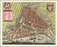
 Atlas Van der Hagen-KW1049B11 087-TABULA ROTERODAMI NOVISSIMA.jpeg 5,500 × 4,596; 5.63 MB
-
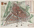
 Rotterdam Map by Frederick De Wit c1690.jpg 11,266 × 9,002; 23.71 MB
-
 1695 - Rotterdam by Johannes de Vou.JPG 3,182 × 2,865; 10.93 MB
-
 Plattegrond van Rotterdam door Johannes de Vou, objectnr 57280(1).JPG 7,057 × 5,916; 38.88 MB
-
 Rotterdam - De Vou+ De Hooghe, 1694.jpg 2,596 × 2,346; 1.67 MB
-
 Atlas de Wit 1698-pl020-Rotterdam-KB PPN 145205088.jpg 2,000 × 1,662; 1.94 MB
-
 Rotterdam - (M. Merian) - btv1b53225501f (1 of 2).jpg 4,157 × 3,353; 4.47 MB
-
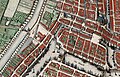
 Blaak, Kolk, Oude Haven, Laurenskerk in Rotterdam Map Detail by Frederick De Wit c1690.jpg 3,000 × 3,151; 2.84 MB
-
 Coolsingel met Binnenwegse of Koolseweg poort, 1649.jpg 1,893 × 1,214; 693 KB
-
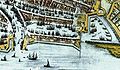
 Haringvliet, Oude Haven, Nieuwe Haven, Blaeck in Rotterdam Map by Frederick De Wit c1690.jpg 5,976 × 4,328; 7.16 MB
-
 Kaart Haringvliet Rotterdam.jpg 713 × 418; 320 KB
-
-
 Oud-Nederlandsche steden in haar ontstaan, groei en ontwikkeling (1909) (14764972982).jpg 2,864 × 2,388; 1.29 MB
-
 Rotterdam Kolk 1626 1652.jpg 900 × 625; 256 KB
-
 Rotterdam Kolk 1626.jpg 450 × 625; 119 KB
-
 Rotterdam Kolk 1652.jpg 450 × 625; 139 KB
.jpg)


.JPG)


_-_btv1b53225501f_(1_of_2).jpg)


_(14764972982).jpg)


