Category:Maps of Schliersee
.jpg) |
Schliersee by year · Schliersee by season (spring · summer · autumn · winter) · Aerial photographs · Animals · Art · Boats · Flora · Frozen · Gallery page · Historic views · Island Wörth · Maps · Panoramics · Views |
Deutsch: Karten zum Schliersee
English: Maps of Schliersee
Media in category "Maps of Schliersee"
The following 4 files are in this category, out of 4 total.
-
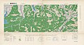 After Action Report - Schliersee - NARA - 100384921.jpg 10,138 × 5,400; 12.25 MB
-
 Geistbeck 1885 - Schliersee.jpg 976 × 1,361; 268 KB
-
 Geistbeck 1885-Waginger Spitzing Tegern Kochel Schliersee Tiefenkarten.jpg 6,748 × 4,779; 7.02 MB
-
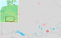 Location Schliersee.PNG 717 × 442; 51 KB


