Category:Maps of Tours
Media in category "Maps of Tours"
The following 48 files are in this category, out of 48 total.
-
 37 INDRE-ET-LOIRE carte grille communale densite INSEE.png 3,507 × 2,480; 3.07 MB
-
 37261-Tours-argile.png 3,057 × 2,480; 6.12 MB
-
 37261-Tours-Cours eau.jpg 3,507 × 2,480; 1.09 MB
-
 37261-Tours-Hydro.jpeg 5,846 × 4,133; 3.76 MB
-
 37261-Tours-Sols.png 3,270 × 2,598; 7.7 MB
-
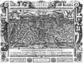
 Braun Tours UBHD.jpg 1,031 × 703; 507 KB
-
 Carte de la ville de Tours en 1619.jpg 1,266 × 620; 140 KB
-

-
 Diocèse Tours 1789.svg 2,000 × 1,922; 801 KB
-

-
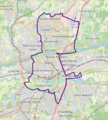
 Map commune FR insee code 37261.png 756 × 605; 128 KB
-
 Map of Tours.jpg 2,444 × 1,617; 1.06 MB
-
 Map Tours.jpg 1,620 × 2,463; 4.03 MB
-

-
 Peutinger Tours.JPG 345 × 210; 33 KB
-
 Plan Caesarodunum.png 850 × 623; 63 KB
-
 Plan Caesarodunum2.png 850 × 623; 43 KB
-
 Plan Caesarodunum3.png 850 × 623; 42 KB
-
 Plan du fond des quartiers de Tours.png 2,480 × 3,507; 474 KB
-
 Plan masse.jpg 923 × 740; 87 KB
-
 Plan Tours siette.jpg 1,215 × 917; 633 KB
-
 Plan-Tours-.jpg 2,461 × 1,667; 1 MB
-
 Province de Tours 1789.svg 2,000 × 1,922; 787 KB
-
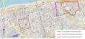
 Périmètre inscrit ville de tours UNESCO PSMV 2004.pdf 1,239 × 1,752; 900 KB
-
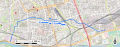
 Railway map of France - Tours - animated - fr.gif 2,216 × 1,441; 15.28 MB
-
 Représentation de l'enceinte de Tours au 14 ème siècle.JPG 960 × 720; 57 KB
-
 Représentation de l'enceinte de Tours au 17 ème siècle.JPG 960 × 720; 52 KB
-
 Temple Caesarodunum.png 850 × 623; 45 KB
-
 Tours - 10e S.svg 1,073 × 484; 366 KB
-
 Tours - enceintes12e S.svg 1,073 × 484; 365 KB
-
 Tours - inondation 1856.jpg 845 × 519; 165 KB
-
 Tours - Inondation 1856.svg 928 × 570; 234 KB
-
 Tours - rempart bastionné.svg 870 × 390; 263 KB
-
 Tours - rue des oiseaux cadastre napoléonien.jpg 644 × 488; 131 KB
-
 Tours - ruisseau Archevêque.svg 916 × 356; 413 KB
-
 Tours - trolleybus 1952.svg 489 × 450; 242 KB
-
 Tours - trolleybus 1965.svg 598 × 523; 241 KB
-
 Tours - trolleybus.svg 598 × 523; 244 KB
-
 Tours cadastre napoléonien amphi.jpg 706 × 479; 211 KB
-
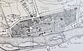
 Tours médievale.jpg 1,892 × 1,441; 2.5 MB
-
 Tours OSM 01.png 462 × 515; 245 KB
-
 Tours OSM 02.png 462 × 515; 308 KB
-
 Tours-.Siette.jpg 2,463 × 1,592; 616 KB
-
 Vieux tours 1890 1900.jpg 3,000 × 1,346; 3.5 MB
-
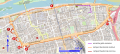
 Vieux Tours périmétre de reconstruction.jpg 3,512 × 1,880; 2.91 MB
-
 Vieux tours,Carte de René Siette 1619.jpg 1,368 × 915; 420 KB
-
 Vieux tours,Plan fayot, 1783,extrait, quartier canoniale du cloitre Saint-Gatien.jpg 2,580 × 1,700; 277 KB
-
 Ville de tours projet PAEE 1933, auteur AGACHE et SAUNIIER architectes urbanistes.jpg 2,472 × 3,000; 8.16 MB


_d%27apr%C3%A8s_l%27arch%C3%A9ologie..png)


_(14779417001).jpg)


