Category:Maps of Town of Southold, New York
Use the appropriate category for maps showing all or a large part of Southold. See subcategories for smaller areas:
| If the map shows | Category to use |
|---|---|
| Southold on a recently created map | Category:Maps of Town of Southold, New York or its subcategories |
| Southold on a map created more than 70 years ago | Category:Old maps of Town of Southold, New York or its subcategories |
| the history of Southold on a recently created map | Category:Maps of the history of Town of Southold, New York or its subcategories |
| the history of Southold on a map created more than 70 years ago | Category:Old maps of the history of Town of Southold, New York or its subcategories |
Media in category "Maps of Town of Southold, New York"
The following 18 files are in this category, out of 18 total.
-

-

-

-
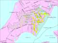
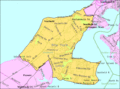
 Cutchogue-ny-map.png 575 × 425; 43 KB
-
 Fisher-island-map.gif 575 × 425; 18 KB
-
 Goldsmith's Inlet.jpg 4,000 × 3,000; 5.09 MB
-
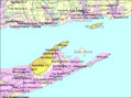
 Greenport-ny-map.gif 575 × 425; 41 KB
-
 Greenport-west-map.gif 575 × 425; 43 KB
-
 Laurel-ny-map.gif 575 × 425; 38 KB
-
 Mattituck-ny-map.gif 575 × 425; 37 KB
-
 New-suffolk-ny-map.gif 575 × 425; 33 KB
-

-
 Orient-ny-map.gif 575 × 425; 20 KB
-
 Orientny.gif 422 × 359; 14 KB
-
 Plum-gull-islands-USGS-1954.jpg 1,167 × 658; 87 KB
-
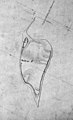 Robbins Island, New York.jpg 1,590 × 2,609; 1.02 MB
-
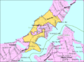
 Southold-city-map.gif 575 × 425; 43 KB
-
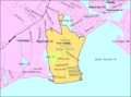
 Southold-town-map.gif 575 × 425; 51 KB


