Category:Maps of Ury (Seine-et-Marne)
Subcategories
This category has only the following subcategory.
Media in category "Maps of Ury (Seine-et-Marne)"
The following 11 files are in this category, out of 11 total.
-
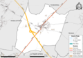
 77477-Ury - Localisation.png 2,500 × 2,480; 1.42 MB
-
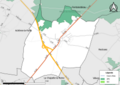
 77477-Ury - Relief-PlanIgn.png 7,015 × 4,960; 6.58 MB
-
 77477-Ury-Cadastre.png 7,015 × 4,960; 6.08 MB
-
 77477-Ury-Hydro.png 7,015 × 4,960; 3.7 MB
-
 77477-Ury-Natura 2000.png 7,015 × 4,960; 2.85 MB
-
 77477-Ury-Orthophoto.png 7,015 × 4,960; 4.65 MB
-
 77477-Ury-Sols.png 7,015 × 4,960; 2.97 MB
-
 77477-Ury-ZNIEFF1.png 7,015 × 4,960; 2.65 MB
-
 77477-Ury-ZNIEFF2.png 7,015 × 4,960; 2.57 MB
-
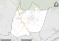
 Gi ury2.jpg 678 × 510; 180 KB
-
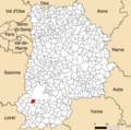
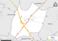
 Map commune FR insee code 77477.png 756 × 605; 39 KB


