Category:Maps of World War II in Europe 1944
Media in category "Maps of World War II in Europe 1944"
The following 33 files are in this category, out of 33 total.
-
-
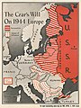
 1944 Chapin map of Romania, Bulgaria and Ukraine during World War II for TIME Magazine.jpg 4,732 × 6,000; 10.07 MB
-

-
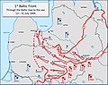 Baltic 13-31 July 1944.jpg 1,434 × 1,133; 254 KB
-
 Doc la Burnoyère sainteny 50500-2.jpg 1,275 × 1,755; 1.27 MB
-
 Doppelkopf 1944.jpg 1,378 × 1,133; 213 KB
-
 Europe Nord-Est (sic) économique illustrée - btv1b53121486z.jpg 9,108 × 6,668; 11.33 MB
-
 German dispositions Greece 021044.jpg 893 × 915; 134 KB
-
 German dispositions Greece 021144.jpg 893 × 916; 126 KB
-
 German dispositions Greece 160944.jpg 894 × 917; 136 KB
-
 German dispositions Greece 211044.jpg 892 × 915; 126 KB
-
 German dispositions Greece 230844.jpg 894 × 917; 126 KB
-
 German withdrawal Greece 1944.jpg 892 × 915; 143 KB
-
 Kesselschlacht von Kamenez-Podolski (Hube-Kessel).png 2,470 × 1,245; 909 KB
-
 Map Monschau Habscheid.jpg 651 × 700; 144 KB
-
 NavWarMap No. 3 - World War 2 in the North Sea Area.jpg 35,225 × 23,739; 285.85 MB
-

-
 Ordnance Installations 15 December 1944 - NARA - 100384775.jpg 10,816 × 6,263; 6.76 MB
-
 PanzerschlachtVorWarschau1944 V2.png 5,219 × 3,526; 2.28 MB
-
 Parcours2eDB.jpg 1,480 × 587; 205 KB
-
 Russian Balkans and Baltic Campaigns 19 August to 31 December 1944.gif 890 × 689; 141 KB
-
 Situation Map No. 2 November 1944 Düren - Eschweiler - Stolberg - NARA - 100385139.jpg 6,608 × 8,750; 5.37 MB
-
 Soviet invasion Bulgaria 1944.png 1,658 × 1,050; 4.12 MB
-
 St Vith Map Ardennes.svg 990 × 630; 68 KB
-
 The Second British Army on D-Day.png 593 × 624; 837 KB
-
 VorlaufPzSchlachtWarchau071944.png 5,292 × 3,484; 3.22 MB
-
 World War II in Europe Western Front situation map, 11-12-1944.jpg 2,223 × 2,635; 1,021 KB
-
 World War II Map - 1 - The Mediterranean.jpg 35,180 × 23,782; 267.47 MB
-
 Битва під Бродами схема 1.jpg 2,032 × 2,624; 3.27 MB
-
 Битва під Бродами схема 2.jpg 5,684 × 4,323; 8.41 MB
-
 Битва під Бродами схема 3.jpg 2,024 × 2,872; 5.11 MB
-

-


_%C3%A9conomique_illustr%C3%A9e_-_btv1b53121486z.jpg)


.png)


_(Operations_21-23_December_1944)_to_Accompany_Report_of_Operations_1-31_December_1944_-_DPLA_-_ddd1b9601880e0eae6d63ab8f26e8123.jpg)


