Category:Maps of ancient Roman roads in France
Media in category "Maps of ancient Roman roads in France"
The following 12 files are in this category, out of 12 total.
-
 Bizeul Carte-VoiesRomaines 1842.jpg 1,097 × 774; 383 KB
-
 C voies romaines Aquitaine.jpg 1,000 × 1,063; 761 KB
-
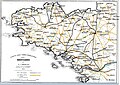
 C voies romaines bretagne.jpg 1,000 × 589; 379 KB
-
 Carte de voies romaines en Bourgogne (11245204446).jpg 800 × 1,321; 181 KB
-
-
 Carte pour la voye romaine entre Clermont et la Sioule (34167564720).jpg 5,879 × 2,213; 7.78 MB
-
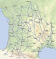
 France map Lambert-93 topographic-ancient Roman roads.svg 1,766 × 1,645; 1.6 MB
-
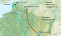 Renty Roman Roads.png 1,123 × 663; 1.14 MB
-
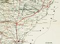
 V ROMAINEBAVAYS NORDdemi copie2 50.jpg 500 × 328; 20 KB
-
 Via Belgica-kaart.png 600 × 223; 15 KB
-
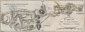
 Voies romaines au départ de Lutèce.png 620 × 512; 800 KB
-
 Voies romaines Gaule.jpg 1,000 × 963; 577 KB


.jpg)


.jpg)