Category:Maps of comarcas of the Community of Madrid
Provinces of Spain: Álava · Albacete · Alicante · Almería · Asturias‡ · Ávila · Badajoz · Balearic Islands‡ · Biscay · Burgos · Cáceres · Cádiz · Cantabria‡ · Castellón · Ciudad Real · Córdoba · A Coruña · Cuenca · Gipuzkoa · Granada · Guadalajara · Huelva · Huesca · Jaén · León · Lugo · Madrid‡ · Málaga · Murcia‡ · Navarre‡ · Ourense · Palencia · Pontevedra · La Rioja‡ · Salamanca · Seville · Soria · Teruel · Toledo · Valencia · Valladolid · Zamora · Zaragoza · Autonomous cities:
‡: uniprovincial autonomous communities.
‡: uniprovincial autonomous communities.
Autonomous communities of Spain: Andalusia · Aragon · Asturias · Balearic Islands · Basque Autonomous Community · Cantabria · Castile and León · Castilla–La Mancha · Catalonia · Extremadura · Galicia · Community of Madrid · Region of Murcia · Navarre · La Rioja · Valencian Community · Autonomous cities:
Subcategories
This category has the following 2 subcategories, out of 2 total.
Media in category "Maps of comarcas of the Community of Madrid"
The following 21 files are in this category, out of 21 total.
-
 Comarcas de la Comunidad de Madrid.png 480 × 363; 34 KB
-
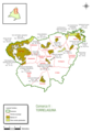
 01-Comarcas de Madrid.svg 400 × 400; 227 KB
-
 7-Comarcas de Madrid.svg 400 × 400; 230 KB
-
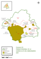
 Comarca forestal 1 de la Comunidad de Madrid (2007) Parque Natural de Peñalara, mapa.png 1,587 × 2,293; 870 KB
-

-
 Comarca forestal 11 de la Comunidad de Madrid (2007) Robledo de Chavela, mapa.png 1,617 × 2,297; 593 KB
-
 Comarca forestal 12 de la Comunidad de Madrid (2007) El Escorial, mapa.png 1,618 × 2,307; 688 KB
-

-

-
-
 Comarca forestal 2 de la Comunidad de Madrid (2007) Lozoya, mapa.png 1,600 × 2,296; 782 KB
-
 Comarca forestal 3 de la Comunidad de Madrid (2007) Buitrago, mapa.png 1,615 × 2,297; 953 KB
-
 Comarca forestal 4 de la Comunidad de Madrid (2007) Montejo, mapa.png 1,617 × 2,299; 1.13 MB
-
 Comarca forestal 5 de la Comunidad de Madrid (2007) Torrelaguna, mapa.png 1,611 × 2,311; 776 KB
-
 Comarca forestal 6 de la Comunidad de Madrid (2007) Alcalá de Henares, mapa.png 1,617 × 2,306; 802 KB
-
 Comarca forestal 7 de la Comunidad de Madrid (2007) Este, mapa.png 1,620 × 2,307; 915 KB
-

-

-
 Comarcas forestales de la Comunidad de Madrid (2007) distribución geográfica, mapa.png 1,622 × 1,772; 694 KB
-
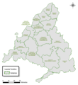
 Mapa comarcal de la Comunidad de Madrid.svg 380 × 413; 69 KB
-
 Subcomarcas Sierra Norte de Madrid.svg 400 × 400; 228 KB


_Parque_Natural_de_Pe%C3%B1alara,_mapa.png)
_San_Mart%C3%ADn_de_Valdeiglesias,_mapa.png)
_Robledo_de_Chavela,_mapa.png)
_El_Escorial,_mapa.png)
_Parque_Regional_de_la_Cuenca_Alta_del_Manzanares._Oeste,_mapa.png)
_Parque_Regional_de_la_Cuenca_Alta_del_Manzanares._Norte,_mapa.png)
_Parque_Regional_de_la_Cuenca_Alta_del_Manzanares._Sur,_mapa.png)
_Lozoya,_mapa.png)
_Buitrago,_mapa.png)
_Montejo,_mapa.png)
_Torrelaguna,_mapa.png)
_Alcal%C3%A1_de_Henares,_mapa.png)
_Este,_mapa.png)
_Parque_Regional_del_Sureste,_mapa.png)
_Parque_Regional_de_la_Cuenca_Media_del_Guadarrama,_mapa.png)
_distribuci%C3%B3n_geogr%C3%A1fica,_mapa.png)

