Category:Maps of districts of Koblenz
Media in category "Maps of districts of Koblenz"
The following 30 files are in this category, out of 30 total.
-
 Karte von Neuendorf in Koblenz.svg 744 × 750; 79 KB
-
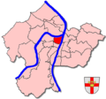 Stadtteilkarte Koblenz-Altstadt.png 650 × 606; 184 KB
-
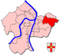 Stadtteilkarte Koblenz-Arenberg.png 650 × 606; 183 KB
-
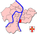
 Stadtteilkarte Koblenz-Arzheim.png 650 × 606; 183 KB
-
 Stadtteilkarte Koblenz-Asterstein.png 650 × 606; 184 KB
-
 Stadtteilkarte Koblenz-Bubenheim.png 650 × 606; 161 KB
-
 Stadtteilkarte Koblenz-Ehrenbreitstein.png 650 × 606; 184 KB
-
 Stadtteilkarte Koblenz-Goldgrube.png 650 × 606; 184 KB
-
 Stadtteilkarte Koblenz-Güls.png 650 × 606; 183 KB
-
 Stadtteilkarte Koblenz-Horchheim.png 650 × 606; 184 KB
-
 Stadtteilkarte Koblenz-Horchheimer Höhe.png 650 × 606; 183 KB
-
 Stadtteilkarte Koblenz-Immendorf.png 650 × 606; 184 KB
-
 Stadtteilkarte Koblenz-Karthause.png 650 × 606; 179 KB
-
 Stadtteilkarte Koblenz-Kesselheim.png 650 × 606; 161 KB
-
 Stadtteilkarte Koblenz-Lay.png 650 × 606; 237 KB
-
 Stadtteilkarte Koblenz-Lützel.png 650 × 606; 161 KB
-
 Stadtteilkarte Koblenz-Metternich.png 650 × 606; 160 KB
-
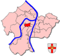
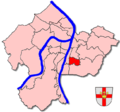
 Stadtteilkarte Koblenz-Mitte.png 650 × 606; 184 KB
-
 Stadtteilkarte Koblenz-Moselweiß.png 650 × 606; 183 KB
-
 Stadtteilkarte Koblenz-Neuendorf.png 650 × 606; 161 KB
-
 Stadtteilkarte Koblenz-Niederberg.png 650 × 606; 184 KB
-
 Stadtteilkarte Koblenz-Oberwerth.png 650 × 606; 184 KB
-
 Stadtteilkarte Koblenz-Pfaffendorf.png 650 × 606; 184 KB
-
 Stadtteilkarte Koblenz-Pfaffendorfer Höhe.png 650 × 606; 184 KB
-
 Stadtteilkarte Koblenz-Rauental.png 650 × 606; 184 KB
-
 Stadtteilkarte Koblenz-Rübenach.png 650 × 606; 182 KB
-
 Stadtteilkarte Koblenz-Stolzenfels.png 650 × 606; 183 KB
-
 Stadtteilkarte Koblenz-Süd.png 650 × 606; 184 KB
-
 Stadtteilkarte Koblenz-Südliche Vorstadt.png 650 × 606; 178 KB
-
 Stadtteilkarte Koblenz-Wallersheim.png 650 × 606; 161 KB


