Category:Maps of districts of Suffolk
Subcategories
This category has the following 9 subcategories, out of 9 total.
B
- Maps of Babergh District (10 F)
E
F
I
M
- Maps of Mid Suffolk District (6 F)
W
- Maps of Waveney District (4 F)
Media in category "Maps of districts of Suffolk"
The following 29 files are in this category, out of 29 total.
-
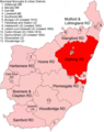
 Blyth RD 1934.png 1,825 × 2,300; 142 KB
-
 Blything RD 1894.png 1,825 × 2,300; 149 KB
-
 Bosmere and Claydon RD 1894.png 1,825 × 2,300; 149 KB
-
 Brandon RD 1894.png 1,470 × 1,740; 81 KB
-
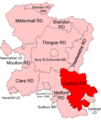
 Clare RD 1894.png 1,470 × 1,740; 80 KB
-
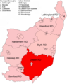
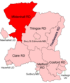
 Clare RD 1935.png 1,470 × 1,740; 73 KB
-
 Cosford RD 1894.png 1,470 × 1,740; 82 KB
-
 Deben RD 1934.png 1,825 × 2,300; 142 KB
-
 East Stow RD 1894.png 1,825 × 2,300; 149 KB
-
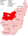
 Gipping RD 1934.png 1,825 × 2,300; 142 KB
-
 Hartismere RD 1894.png 1,825 × 2,300; 149 KB
-
 Hartismere RD 1934.png 1,825 × 2,300; 142 KB
-
 Hoxne RD 1894.png 1,825 × 2,300; 149 KB
-
 Lothingland RD 1934.png 1,825 × 2,300; 141 KB
-
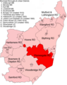
 Melford RD 1894.png 1,470 × 1,740; 82 KB
-
 Melford RD 1935.png 1,470 × 1,740; 73 KB
-
 Mildenhall RD 1894.png 1,470 × 1,740; 82 KB
-
 Mildenhall RD 1935.png 1,470 × 1,740; 73 KB
-
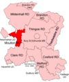 Moulton RD 1894.png 1,470 × 1,740; 81 KB
-
 Mutford and Lothingland RD 1894.png 1,825 × 2,300; 148 KB
-
 Plomesgate RD 1894.png 1,825 × 2,300; 149 KB
-
 Samford RD 1894.png 1,825 × 2,300; 149 KB
-
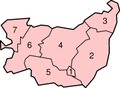 SuffolkNumbered.png 200 × 147; 13 KB
-
 Thedwastre RD 1894.png 1,470 × 1,740; 81 KB
-
 Thingoe RD 1894.png 1,470 × 1,740; 82 KB
-
 Thingoe RD 1935.png 1,470 × 1,740; 74 KB
-
 Wainford RD 1934.png 1,825 × 2,300; 142 KB
-
 Wangford RD 1894.png 1,825 × 2,300; 149 KB
-
 Woodbridge RD 1894.png 1,825 × 2,300; 149 KB


