Category:Maps of districts of Trabzon Province
Media in category "Maps of districts of Trabzon Province"
The following 21 files are in this category, out of 21 total.
-
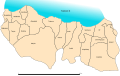 Trabzon (tr).svg 956 × 600; 31 KB
-
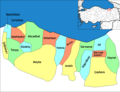 Trabzon districts.png 1,013 × 773; 53 KB
-
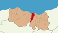
 Trabzon location districts.png 875 × 500; 90 KB
-
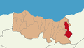
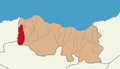
 Trabzon location Akçaabat.PNG 875 × 500; 43 KB
-
 Trabzon location Araklı.PNG 875 × 500; 43 KB
-
 Trabzon location Arsin.PNG 875 × 500; 43 KB
-
 Trabzon location Beşikdüzü.PNG 875 × 500; 43 KB
-
 Trabzon location Dernekpazarı.PNG 875 × 500; 43 KB
-
 Trabzon location Düzkoy.PNG 875 × 500; 43 KB
-
 Trabzon location Hayrat.PNG 875 × 500; 43 KB
-
 Trabzon location Köprübaşı.PNG 875 × 500; 43 KB
-
 Trabzon location Maçka.PNG 875 × 500; 43 KB
-
 Trabzon location Of.PNG 875 × 500; 43 KB
-
 Trabzon location Ortahisar.PNG 875 × 500; 43 KB
-
 Trabzon location Sürmene.PNG 875 × 500; 43 KB
-
 Trabzon location Tonya.PNG 875 × 500; 43 KB
-
 Trabzon location Vakfıkebir.PNG 875 × 500; 43 KB
-
 Trabzon location Yomra.PNG 875 × 500; 43 KB
-
 Trabzon location Çarşıbaşı.PNG 875 × 500; 43 KB
-
 Trabzon location Çaykara.PNG 875 × 500; 43 KB
-
 Trabzon location Şalpazarı.PNG 875 × 500; 43 KB
.svg)


