Category:Maps of districts of the Eastern Cape
Media in category "Maps of districts of the Eastern Cape"
The following 16 files are in this category, out of 16 total.
-
 Map of South Africa with Alfred Nzo highlighted (2016).svg 809 × 709; 719 KB
-
 Map of the Eastern Cape with Alfred Nzo highlighted (2016).svg 928 × 620; 671 KB
-
 Map of South Africa with Amathole highlighted (2016).svg 809 × 709; 728 KB
-
 Map of the Eastern Cape with Amathole highlighted (2016).svg 928 × 620; 689 KB
-
 Map of South Africa with Buffalo City highlighted (2016).svg 809 × 709; 707 KB
-
 Map of the Eastern Cape with Buffalo City highlighted (2016).svg 928 × 620; 640 KB
-
 Map of South Africa with Chris Hani highlighted (2016).svg 809 × 709; 720 KB
-
 Map of the Eastern Cape with Chris Hani highlighted (2016).svg 928 × 620; 657 KB
-
 Map of South Africa with Joe Gqabi highlighted (2016).svg 809 × 709; 723 KB
-
 Map of the Eastern Cape with Joe Gqabi highlighted (2016).svg 928 × 620; 672 KB
-
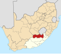
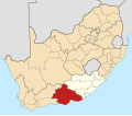
 Map of South Africa with Nelson Mandela Bay highlighted (2016).svg 809 × 709; 704 KB
-
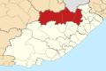
 Map of the Eastern Cape with Nelson Mandela Bay highlighted (2016).svg 928 × 620; 631 KB
-
 Map of South Africa with OR Tambo highlighted (2016).svg 809 × 709; 719 KB
-
 Map of the Eastern Cape with OR Tambo highlighted (2016).svg 928 × 620; 672 KB
-
 Map of South Africa with Sarah Baartman highlighted (2016).svg 809 × 709; 724 KB
-
 Map of the Eastern Cape with Sarah Baartman highlighted (2016).svg 928 × 620; 669 KB
.svg)
.svg)
.svg)
.svg)
.svg)
.svg)
.svg)
.svg)
.svg)
.svg)
.svg)
.svg)
.svg)
.svg)
.svg)
.svg)