Category:Maps of earthquakes in Philippines
Subcategories
This category has only the following subcategory.
Media in category "Maps of earthquakes in Philippines"
The following 86 files are in this category, out of 86 total.
-
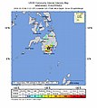
 2018-11-04 Sapad, Philippines M6 earthquake intensity map (USGS).jpg 612 × 684; 89 KB
-

-

-

-

-

-

-

-

-

-

-

-

-

-

-
-
-
-
 2020-08-01 Litayan, Philippines M6.4 earthquake intensity map (USGS).jpg 612 × 684; 105 KB
-
 2020-08-01 Polloc, Philippines M6.4 earthquake intensity map (USGS).jpg 612 × 684; 106 KB
-

-

-

-
 2020-11-15 Marihatag, Philippines M6 earthquake intensity map (USGS).jpg 612 × 684; 111 KB
-

-

-

-

-

-

-
 2021-02-07 Bansalan, Philippines M6 earthquake intensity map (USGS).jpg 612 × 684; 103 KB
-
 2021-02-07 Magsaysay, Philippines M6 earthquake intensity map (USGS).jpg 612 × 684; 102 KB
-

-
 2021-07-23 Hukay, Philippines M6.7 earthquake intensity map (USGS).jpg 612 × 684; 110 KB
-
 2021-07-23 Tingloy, Philippines M6.7 earthquake intensity map (USGS).jpg 612 × 684; 111 KB
-
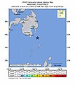
 2021-08-11 Bobon, Philippines M7.1 earthquake intensity map (USGS).jpg 612 × 684; 102 KB
-
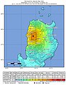
 2021-08-11 Bobon, Philippines M7.1 earthquake shakemap (USGS).jpg 787 × 1,001; 214 KB
-

-
 2021-08-11 Pondaguitan, Philippines M7.1 earthquake shakemap (USGS).jpg 787 × 994; 214 KB
-

-
 2022-01-22 Sarangani, Philippines M6 earthquake shakemap (USGS).jpg 779 × 995; 148 KB
-
 2022-03-13 Cabra, Philippines M6.4 earthquake intensity map (USGS).jpg 612 × 684; 108 KB
-
 2022-03-13 Cabra, Philippines M6.4 earthquake shakemap (USGS).jpg 805 × 1,000; 122 KB
-
 2022-03-13 Luzon, Philippines M6.4 earthquake intensity map (USGS).jpg 612 × 684; 107 KB
-
 2022-03-13 Luzon, Philippines M6.4 earthquake shakemap (USGS).jpg 788 × 997; 118 KB
-
 2022-04-19 Manay, Philippines M6.2 earthquake intensity map (USGS).jpg 612 × 684; 102 KB
-
 2022-04-19 Manay, Philippines M6.2 earthquake shakemap (USGS).jpg 780 × 1,003; 117 KB
-

-
 2022-04-19 Santiago, Philippines M6.1 earthquake shakemap (USGS).jpg 780 × 998; 112 KB
-
 2022-04-20 Manay, Philippines M6 earthquake intensity map (USGS).jpg 612 × 684; 100 KB
-
 2022-04-20 Manay, Philippines M6 earthquake shakemap (USGS).jpg 780 × 1,001; 109 KB
-

-
 2022-05-05 Lukatan, Philippines M6 earthquake shakemap (USGS).jpg 780 × 1,003; 102 KB
-

-
 2022-05-21 Bungahan, Philippines M6.1 earthquake shakemap (USGS).jpg 788 × 998; 128 KB
-
 2022-05-21 Lian, Philippines M6.1 earthquake intensity map (USGS).jpg 612 × 684; 112 KB
-
 2022-05-21 Lian, Philippines M6.1 earthquake shakemap (USGS).jpg 788 × 1,001; 127 KB
-

-
 2022-06-30 Namuac, Philippines M6 earthquake shakemap (USGS).jpg 788 × 998; 103 KB
-

-
 2022-07-27 Bantay, Philippines M7 earthquake shakemap (USGS).jpg 775 × 1,004; 130 KB
-

-
 2022-07-27 Dolores, Philippines M7 earthquake shakemap (USGS).jpg 775 × 1,004; 130 KB
-

-
 2022-07-27 Dolores, Philippines M7.1 earthquake shakemap (USGS).jpg 788 × 998; 132 KB
-

-
 2022-10-25 Dolores, Philippines M6.4 earthquake shakemap (USGS).jpg 788 × 998; 130 KB
-

-
 2022-10-25 Luzon, Philippines M6.4 earthquake shakemap (USGS).jpg 788 × 1,002; 133 KB
-
 2023-02-01 Babag, Philippines M6 earthquake intensity map (USGS).jpg 612 × 684; 108 KB
-
 2023-02-01 Babag, Philippines M6 earthquake shakemap (USGS).jpg 780 × 997; 138 KB
-
 2023-02-01 Mindanao, Philippines M6 earthquake intensity map (USGS).jpg 612 × 684; 109 KB
-
 2023-02-01 Mindanao, Philippines M6 earthquake shakemap (USGS).jpg 780 × 1,000; 138 KB
-

-
 2023-02-15 Masbate region, Philippines M6.1 earthquake shakemap (USGS).jpg 788 × 1,000; 151 KB
-
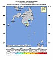
 2023-02-15 Miaga, Philippines M6.1 earthquake intensity map (USGS).jpg 612 × 684; 119 KB
-
 2023-02-15 Miaga, Philippines M6.1 earthquake shakemap (USGS).jpg 788 × 1,000; 151 KB
-

-
 2023-03-07 San Mariano, Philippines M6 earthquake shakemap (USGS).jpg 780 × 998; 138 KB
-
 2023-04-04 Gigmoto, Philippines M6.2 earthquake intensity map (USGS).jpg 612 × 684; 104 KB
-
 2023-04-04 Gigmoto, Philippines M6.2 earthquake shakemap (USGS).jpg 788 × 1,001; 96 KB
-
 Atlas of the Philippine Islands (1900) map 06.jpg 5,000 × 6,000; 4.93 MB
-
 Earthquake map mag.png 510 × 542; 473 KB
-
 ECDM 20221026 EQ Philippines.pdf 1,625 × 1,125; 797 KB
-
 July 09 2019 - 5.6 Makilala Quake.png 1,280 × 720; 202 KB
-
 Philippine plate tectonics and earthquakes.png 2,438 × 3,508; 5.22 MB
.jpg)
.jpg)
.jpg)
.jpg)
.jpg)
.jpg)
.jpg)
.jpg)
.jpg)
.jpg)
.jpg)
.jpg)
.jpg)
.jpg)
.jpg)
.jpg)
.jpg)
.jpg)
.jpg)
.jpg)
.jpg)
.jpg)
.jpg)
.jpg)
.jpg)
.jpg)
.jpg)
.jpg)
.jpg)
.jpg)
.jpg)
.jpg)
.jpg)
.jpg)
.jpg)
.jpg)
.jpg)
.jpg)
.jpg)
.jpg)
.jpg)
.jpg)
.jpg)
.jpg)
.jpg)
.jpg)
.jpg)
.jpg)
.jpg)
.jpg)
.jpg)
.jpg)
.jpg)
.jpg)
.jpg)
.jpg)
.jpg)
.jpg)
.jpg)
.jpg)
.jpg)
.jpg)
.jpg)
.jpg)
.jpg)
.jpg)
.jpg)
.jpg)
.jpg)
.jpg)
.jpg)
.jpg)
.jpg)
.jpg)
.jpg)
.jpg)
.jpg)
.jpg)
.jpg)
.jpg)
.jpg)
_map_06.jpg)


