Category:Maps of former districts of Styria
States of Austria:  Styria ·
Subcategories
This category has the following 6 subcategories, out of 6 total.
F
- Maps of Bezirk Feldbach (2 F)
- Maps of Bezirk Fürstenfeld (2 F)
H
- Maps of Bezirk Hartberg (59 F)
L
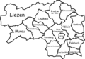
- Locator maps of Bezirk Judenburg (52 F)
R
- Maps of Bezirk Radkersburg (2 F)
Media in category "Maps of former districts of Styria"
The following 20 files are in this category, out of 20 total.
-
 Bezirk Bruck an der Mur in Österreich.png 692 × 359; 88 KB
-
 Karte A Stmk BM.svg 1,050 × 730; 26 KB
-
 Karte A Stmk BM+MZ.svg 1,050 × 730; 32 KB
-
 Bezirk Feldbach in Österreich.png 692 × 359; 88 KB
-
 Karte Aut Stmk FB.png 300 × 209; 5 KB
-
 Bezirk Fürstenfeld in Österreich.png 692 × 359; 88 KB
-
 Bezirk Hartberg in Österreich.png 692 × 359; 88 KB
-
 Karte Aut Stmk HB.png 300 × 209; 5 KB
-
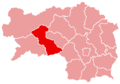
 Bezirk Judenburg in Österreich.png 692 × 359; 88 KB
-
 Karte Aut Stmk JU.png 300 × 209; 4 KB
-
 800px-Karte Aut Stmk Bezirke.png 800 × 561; 178 KB
-
 Karte Aut Stmk BM (bis 2012).png 300 × 209; 5 KB
-
 Karte Aut Stmk RA.png 300 × 209; 5 KB
-
 Bezirk Knittelfeld in Österreich.png 692 × 359; 88 KB
-
 Karte Aut Stmk KF.png 300 × 209; 4 KB
-
 Karte Aut Stmk BA.png 300 × 209; 5 KB
-
 Map of Styria, districts (2015).png 1,000 × 700; 163 KB
-
 Bezirk Mürzzuschlag in Österreich.png 692 × 359; 88 KB
-
 Karte Aut Stmk MZ.png 300 × 209; 5 KB
-
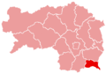
 Bezirk Radkersburg in Österreich.png 692 × 359; 88 KB


.png)


.png)


