Category:Maps of historic districts on the National Register of Historic Places in Oregon
States of the United States: Alaska · Arkansas · Connecticut · Georgia · Idaho · Illinois · Indiana · Iowa · Louisiana · Maryland · Massachusetts · Michigan · Mississippi · Nebraska · New Jersey · New York · North Carolina · Ohio · Oregon · Pennsylvania · Rhode Island · Texas · Virginia · Washington · West Virginia · Wyoming
Puerto Rico
Puerto Rico
Media in category "Maps of historic districts on the National Register of Historic Places in Oregon"
The following 58 files are in this category, out of 58 total.
-
 Ashland Downtown HD boundary map.png 634 × 507; 242 KB
-
 Ashland Railroad Addition HD boundary map.png 1,101 × 727; 447 KB
-
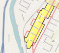
 Astoria Downtown HD boundary map.png 1,021 × 538; 149 KB
-
 Avery–Helm HD boundary map.png 617 × 825; 340 KB
-
 Baker HD boundary map.png 1,565 × 2,549; 1.52 MB
-
 Beaverton Downtown HD boundary map.png 1,122 × 1,192; 369 KB
-
 Beaverton Downtown HD contributing resources.png 1,122 × 1,192; 366 KB
-
 Clackamas Lake Ranger Station map.PNG 800 × 598; 178 KB
-
 Coburg HD boundary map.png 2,037 × 1,911; 828 KB
-
 College Hill West HD boundary map.png 1,021 × 769; 270 KB
-
 Condon Commercial HD boundary map.png 1,300 × 2,867; 452 KB
-
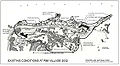
 Condon Commercial HD contributing resources.png 1,300 × 2,867; 472 KB
-
 Drake Park Neighborhood HD boundary map.png 1,325 × 1,119; 508 KB
-
 East Portland Grand Avenue HD boundary map.png 1,194 × 3,187; 997 KB
-
 East Portland Grand Avenue HD contributing resources.png 3,187 × 1,194; 1.01 MB
-
 Gardiner HD boundary map.png 779 × 993; 100 KB
-
 Grants Pass G Street HD boundary map.png 763 × 519; 169 KB
-
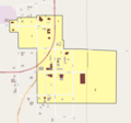
 Independence HD boundary map.png 2,112 × 1,846; 582 KB
-
 Kenton Commercial Historic District Map.png 897 × 673; 252 KB
-
 Kings Hill HD boundary map with titles.png 1,800 × 1,994; 1.32 MB
-
 Kings Hill HD boundary map.png 1,800 × 1,627; 1.18 MB
-
 La Grande Commercial HD boundary map.png 795 × 739; 240 KB
-
 Laurelwood HD boundary map.png 1,781 × 1,175; 407 KB
-
 McMinnville Downtown HD boundary map.png 2,983 × 1,288; 386 KB
-
 Medford Downtown HD boundary map.png 1,057 × 865; 477 KB
-
 Medford Geneva-Minnesota HD boundary map.png 767 × 447; 121 KB
-
 Mill-Pine Neighborhood HD boundary map.png 784 × 706; 236 KB
-
 Munson Valley Historic District map.jpg 296 × 478; 30 KB
-
 Munson Valley Historic District map.png 283 × 323; 51 KB
-
 Oak Hills HD boundary map.png 1,213 × 1,375; 994 KB
-
 Oakland HD boundary map.png 968 × 797; 264 KB
-
 Old McKenzie Fish Hatchery Site map.JPG 2,274 × 2,257; 675 KB
-
 Old Town HD (Bend Oregon) boundary map.png 1,800 × 1,087; 573 KB
-
 Oregon Caves Historic District map.jpg 300 × 316; 23 KB
-
 Portland New Chinatown-Japantown HD boundary map.png 1,334 × 2,081; 710 KB
-
 Portland Thirteenth Avenue HD boundary map.png 1,644 × 2,364; 825 KB
-
 Portland Yamhill HD boundary map.png 2,300 × 1,676; 901 KB
-
 Rim Village map, 2002.jpg 561 × 309; 43 KB
-
 Roseburg Downtown HD boundary map.png 1,070 × 853; 386 KB
-
 Salem Downtown State Street - Commercial Street HD boundary map.png 2,182 × 1,694; 1.41 MB
-
 Shaniko HD boundary map.png 2,008 × 1,879; 282 KB
-
 Shaniko HD contributing resources.png 1,836 × 1,876; 289 KB
-
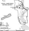 Shirk Ranch Historic District, Lake County, Oregon.png 679 × 708; 167 KB
-
 Shively-McClure HD boundary map.png 961 × 831; 233 KB
-
 Silverton Commercial HD boundary map.png 663 × 788; 174 KB
-
 Siskiyou-Hargadine HD boundary map.png 1,088 × 953; 458 KB
-
 South Main Street Commercial HD boundary map.png 1,825 × 2,030; 1.02 MB
-
 South Main Street Commercial HD contributing resources.png 1,825 × 2,030; 1.02 MB
-
 South Oakdale HD boundary map.png 479 × 965; 160 KB
-
 South Portland HD boundary map.png 1,956 × 1,980; 1.83 MB
-
 St. Helens Downtown HD boundary map.png 1,241 × 1,625; 413 KB
-
 The Dalles Commercial HD boundary map.png 2,161 × 1,617; 1.59 MB
-
 The Dalles Commercial HD contributing resources.png 2,161 × 1,617; 1.61 MB
-
 Trevitts Addition HD boundary map.png 1,448 × 1,106; 524 KB
-
 Union Main Street HD boundary map.png 632 × 1,356; 241 KB
-
 Uniontown-Alameda HD boundary map.png 1,252 × 850; 267 KB
-
 Weston Commercial HD boundary map.png 791 × 855; 130 KB
-
 Weston Commercial HD contributing resources.png 791 × 855; 124 KB


_boundary_map.png)


