Category:Maps of industrial areas in Italy
Media in category "Maps of industrial areas in Italy"
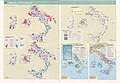
The following 22 files are in this category, out of 22 total.
-

-

-
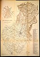 Carta topografica laniera del Comune di Prato (1918).jpg 4,543 × 6,532; 17.66 MB
-

-

-

-

-

-

-
-

-
 Map Dimensional aspects of industry 1992 - Touring Club Italiano CART-TEM-077.jpg 5,000 × 3,468; 9.56 MB
-
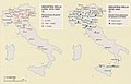
 Map Early industrialization 1992 - Touring Club Italiano CART-TEM-073.jpg 5,000 × 3,467; 9.7 MB
-
 Map Industrial employment 1989 - Touring Club Italiano CART-TEM-074.jpg 5,000 × 3,450; 10.21 MB
-
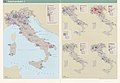 Map Industrial productions I 1990 - Touring Club Italiano CART-TEM-075.jpg 5,000 × 3,476; 9.66 MB
-
 Map Industrial productions II 1990 - Touring Club Italiano CART-TEM-076.jpg 5,000 × 3,402; 9.05 MB
-
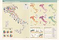
 Map Industry in the Mezzogiorno 1989 - Touring Club Italiano CART-TEM-079.jpg 5,000 × 3,447; 10.62 MB
-
 Map Italian industry in the world 1990 - Touring Club Italiano CART-TEM-078.jpg 5,000 × 3,387; 10.8 MB
-
 Map Service industries 1992 - Touring Club Italiano CART-TEM-081.jpg 5,000 × 3,416; 10.59 MB
-
 Map Types of industries 1992 - Touring Club Italiano CART-TEM-080.jpg 5,000 × 3,488; 10.8 MB
-
-


.jpg)


