Category:Maps of landmarks in Paris
Subcategories
This category has the following 7 subcategories, out of 7 total.
N
P
Media in category "Maps of landmarks in Paris"
The following 30 files are in this category, out of 30 total.
-
-

-
-
 Alexandre Vuillemin, Nouveau plan illustré de la ville de Paris, 1844 - Getty Center.jpg 8,000 × 6,314; 15.95 MB
-
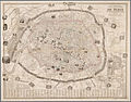
 Auguste Logerot, Nouveau plan itinéraire de la ville de Paris, 1841 - e-rara.jpg 6,630 × 4,760; 36.91 MB
-
 Bernardin-Béchet, Environs de Paris illustrés, 1867 - Gallica.jpg 9,008 × 6,588; 11.19 MB
-
 Bénard, Nouveau plan illustré de la ville de Paris, 1857.jpg 4,364 × 3,436; 3.37 MB
-
 ClercClerc, Plan von Paris, 1869 - Gallica.jpg 8,950 × 7,669; 14.09 MB
-
 Guide to Paris and its Exhibition, 1878. With plan of Paris - The British Library.jpg 5,580 × 4,400; 6.47 MB
-
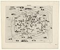
 Guilmin map of Paris, France, Monuments - Geographicus - Paris-Guilmin.jpg 5,000 × 3,680; 5.84 MB
-
 Illustrated map of Paris - Norman B. Leventhal Map Center.jpg 6,521 × 4,759; 5.13 MB
-
 Jacques-François Bénard, Plan pittoresque de la ville de Paris, 1846 - Gallica.jpg 10,754 × 7,277; 15.98 MB
-
 Maillard, Paris illustré et ses fortifications.jpg 4,382 × 3,422; 8.36 MB
-
 Monuments et vues des environs de Paris by L. Poulmaire - Princeton University Library.jpg 10,925 × 8,170; 113.63 MB
-
 Nouveau plan de Paris illustré avec toutes ses fortifications... 1855 - Gallica.jpg 10,871 × 7,615; 22.51 MB
-
 Nouveau Plan de Paris monumental, financier, industriel et commercial - Gallica.jpg 10,251 × 7,640; 14.21 MB
-
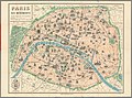
 Nouveau plan de Paris monumental, financier, industriel et commercial, 1895 - Gallica.jpg 9,688 × 7,855; 15.06 MB
-
 Nouveau plan illustré de la ville de Paris, 1852 - Norman B. Leventhal Map Center.jpg 8,596 × 6,693; 13.09 MB
-
-
 Paris by Buland, 1855 - Gallica.jpg 9,244 × 7,713; 16.33 MB
-
 Paris en 1878. Souvenir de l'Exposition universelle Plan simplifié - Gallica.jpg 9,917 × 8,388; 16.03 MB
-
 Paris et ses environs - Penn State University Libraries.jpg 9,384 × 7,060; 11.94 MB
-
 Paris monumental et ses environs - Norman B. Leventhal Map Center.jpg 5,256 × 4,192; 3.99 MB
-
 Paris, ses monuments et ses ruines, 1870-71 - Gallica.jpg 8,070 × 6,479; 11.48 MB
-
 Plan pittoresque de la ville de Paris - Flickr.jpg 2,000 × 1,270; 2.5 MB
-
 Plan pittoresque de la ville de Paris - Norman B. Leventhal Map Center, original.jpg 8,132 × 5,164; 38.24 MB
-
 Plan pittoresque de la ville de Paris - Norman B. Leventhal Map Center.tif 8,132 × 5,164; 120.17 MB
-
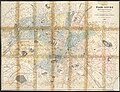
 Robelin, Paris et ses environs, 1911 - David Rumsey.jpg 18,256 × 13,430; 85.6 MB
-
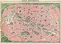
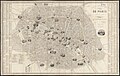
 Rougeron-Vignerol, Nouveau Plan de Paris monumental - Gallica.jpg 11,450 × 8,403; 15.04 MB
-
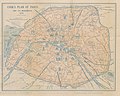
 Taride, Paris Ses Monuments. Guide Pratique Du Visiteur, 1905 - David Rumsey.jpg 18,276 × 13,616; 68.71 MB
.jpg)


