Category:Maps of local government areas in Brisbane
Media in category "Maps of local government areas in Brisbane"
The following 19 files are in this category, out of 19 total.
-
 BrisbaneCity-QldLGA.svg 1,200 × 1,000; 3.94 MB
-
 IpswichCity-QldLGA.svg 1,200 × 1,000; 1.82 MB
-
 LoganCity-QldLGA.svg 1,200 × 1,000; 1.85 MB
-
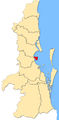
 Moreton bay LGA Qld 2008.png 124 × 159; 10 KB
-
 MoretonBayRegion-QldLGA.svg 1,200 × 1,000; 2.02 MB
-
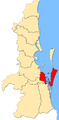
 Old lga Caboolture.png 135 × 175; 14 KB
-
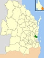
 RedlandCity-QldLGA.svg 1,200 × 1,000; 2.09 MB
-
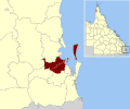
 SEQ-Councils-Brisbane.png 820 × 1,280; 310 KB
-
 SEQ-Councils-Ipswich.png 820 × 1,280; 310 KB
-
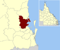
 SEQ-Councils-Logan.png 820 × 1,280; 311 KB
-
 SEQ-Councils-MoretonBay.png 820 × 1,280; 309 KB
-
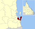
 SEQ-Councils-Redland.png 820 × 1,280; 315 KB
-
 SEQ-U-LGA-map-BCC.png 1,390 × 2,836; 381 KB
-
 SEQ-U-LGA-map-CSC.png 1,390 × 2,836; 380 KB
-
 SEQ-U-LGA-map-ICC.png 1,390 × 2,836; 382 KB
-
 SEQ-U-LGA-map-LCC.png 1,390 × 2,836; 381 KB
-
 SEQ-U-LGA-map-PRSC.png 1,390 × 2,836; 381 KB
-
 SEQ-U-LGA-map-RCC.png 1,390 × 2,836; 381 KB
-
 SEQ-U-LGA-map-RSC.png 1,390 × 2,836; 382 KB


