Category:Maps of municipalities in the district of Thal
Subcategories
This category has the following 2 subcategories, out of 2 total.
Media in category "Maps of municipalities in the district of Thal"
The following 9 files are in this category, out of 9 total.
-
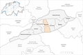
 Karte Gemeinden des Bezirks Thal 2021.png 1,476 × 982; 272 KB
-
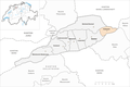
 Karte Gemeinde Aedermannsdorf 2021.png 1,476 × 982; 273 KB
-
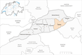 Karte Gemeinde Balsthal 2021.png 1,476 × 982; 273 KB
-
 Karte Gemeinde Herbetswil 2021.png 1,476 × 982; 272 KB
-
 Karte Gemeinde Holderbank SO 2021.png 1,476 × 982; 272 KB
-
 Karte Gemeinde Laupersdorf 2021.png 1,476 × 982; 272 KB
-
 Karte Gemeinde Matzendorf 2021.png 1,476 × 982; 272 KB
-
 Karte Gemeinde Mümliswil-Ramiswil 2021.png 1,476 × 982; 272 KB
-
 Karte Gemeinde Welschenrohr-Gänsbrunnen 2021.png 1,476 × 982; 272 KB


