Category:Maps of municipalities in the district of Uster
Subcategories
This category has the following 2 subcategories, out of 2 total.
U
Media in category "Maps of municipalities in the district of Uster"
The following 10 files are in this category, out of 10 total.
-
 Karte Gemeinden des Bezirks Uster 2007.png 1,476 × 1,193; 431 KB
-
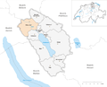 Karte Gemeinde Dübendorf 2007.png 1,476 × 1,193; 432 KB
-
 Karte Gemeinde Egg ZH 2007.png 1,476 × 1,193; 432 KB
-
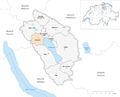 Karte Gemeinde Fällanden 2007.png 1,476 × 1,193; 432 KB
-
 Karte Gemeinde Greifensee 2007.png 1,476 × 1,193; 432 KB
-
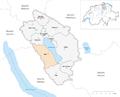 Karte Gemeinde Maur 2007.png 1,476 × 1,193; 432 KB
-
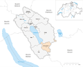 Karte Gemeinde Mönchaltorf 2007.png 1,476 × 1,193; 432 KB
-
 Karte Gemeinde Schwerzenbach 2007.png 1,476 × 1,193; 432 KB
-
 Karte Gemeinde Volketswil 2007.png 1,476 × 1,193; 432 KB
-
 Karte Gemeinde Wangen-Brüttisellen 2007.png 1,476 × 1,193; 432 KB


