Category:Maps of natural disasters
Subcategories
This category has the following 13 subcategories, out of 13 total.
!
C
- Maps of coldness events (59 F)
D
- Debris flow maps (3 F)
- Maps of dust storms (2 F)
E
H
L
M
S
V
W
Media in category "Maps of natural disasters"
The following 19 files are in this category, out of 19 total.
-
 2022 Pakistan Floods - August 27, 2021 vs. August 27, 2022 in Sindh.jpg 8,830 × 5,792; 8.53 MB
-

-
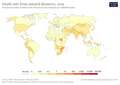 Death-rate-from-natural-disasters-gbd (OWID 0324).png 850 × 600; 99 KB
-
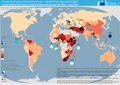
 Deaths-from-natural-disasters (OWID 0301).png 850 × 600; 93 KB
-
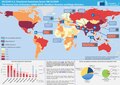 ECDM 20201208 Deadliest disasters human cost for 2000-2019 UCPM.pdf 1,754 × 1,239; 1.2 MB
-
 ECDM 20210301 Disasters human cost by country for 2000-2019 map2V2.pdf 1,754 × 1,239; 1.28 MB
-
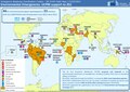
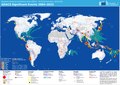 ECDM 20220516 GDACS 2004-2022(1).pdf 2,479 × 1,754; 894 KB
-
 ECDM 20221103 DM Disasters20212022Overview CLIMA.pdf 1,754 × 1,239; 1.06 MB
-
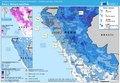 ECDM 20230313 ST Peru.pdf 1,625 × 1,125; 527 KB
-
 ECDM 20230327 DM UCPM environmentalsupport JEU.pdf 1,754 × 1,239; 1.29 MB
-
 ECDM 20230629 DM Disasters2021-2022Overview CLIMA(2).pdf 1,754 × 1,239; 734 KB
-
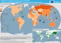
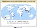 Global Multihazard Frequency and Distribution (5457317005).jpg 3,177 × 2,470; 889 KB
-
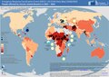
 Global Multihazard Mortality Risks and Distribution (5457923756).jpg 3,081 × 2,332; 1.16 MB
-
 Global Multihazard Proportional Economic Loss Risk Deciles (5457317101).jpg 3,131 × 2,470; 1,004 KB
-
 Global Multihazard Total Economic Loss Risk Deciles (5457923860).jpg 3,150 × 2,470; 1.02 MB
-
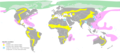
 Natural disasters caused by climate change NO.png 1,425 × 625; 101 KB
-
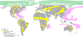
 Natural disasters caused by climate change-da.png 1,425 × 625; 103 KB
-
 Natural disasters caused by climate change-es.png 1,425 × 625; 67 KB
-
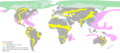 Natural disasters caused by climate change.png 1,425 × 625; 102 KB


.png)
.png)
.jpg)
.jpg)
.jpg)
.jpg)


