Category:Maps of neighborhoods in Samsun
Media in category "Maps of neighborhoods in Samsun"
The following 11 files are in this category, out of 11 total.
-
 Altınkum, Atakent, Atakum, Çatalçam, Kurupelit, Taflan ve merkez.svg 1,488 × 1,052; 194 KB
-
 Ağcagüney, Çınarlık, Dikbıyık, Hürriyet ve Çarşamba.svg 1,052 × 1,488; 744 KB
-
 Ballıca, Çetinkaya, Doğanca, İkizpınar, Kolay ve Bafra.svg 2,105 × 1,488; 561 KB
-
 Dereköy, Yörükler ve 19 Mayıs.svg 1,052 × 1,488; 80 KB
-
 Neighbourhoods of 19 Mayıs.svg 1,052 × 1,488; 102 KB
-
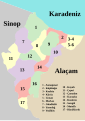
 Neighbourhoods of Atakum.svg 1,488 × 1,052; 229 KB
-
 Neighbourhoods of Bafra.svg 2,105 × 1,488; 709 KB
-
 Neighbourhoods of Yakakent.svg 744 × 1,052; 50 KB
-
 Neighbourhoods of Çarşamba.svg 1,052 × 1,488; 833 KB
-
 Neighbourhoods of İlkadım.svg 1,488 × 2,105; 587 KB
-
 Yeşilkent, İlkadım, Gazi ve merkez.svg 1,488 × 2,105; 542 KB


