Category:Maps of regions of the Dominican Republic
Media in category "Maps of regions of the Dominican Republic"
The following 18 files are in this category, out of 18 total.
-

-
 Blancos en RD1.png 800 × 573; 33 KB
-
 Blancos en RD2.png 800 × 573; 33 KB
-
 CIBAO.png 794 × 570; 22 KB
-
 Cocolos in Dominican Republic.PNG 800 × 573; 28 KB
-
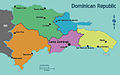 Dominican Republic Regions map.jpg 1,608 × 1,001; 401 KB
-
 ELCIBAO.png 794 × 570; 31 KB
-
 Geo Regions DR met naam.JPG 794 × 570; 80 KB
-
 Geographic Regions of the Dominican Republic.JPG 794 × 570; 64 KB
-
 Map of Geographic Regions of the Dominican Republic-2.png 1,244 × 893; 64 KB
-
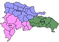
 Map of Geographic Regions of the Dominican Republic.PNG 794 × 570; 33 KB
-
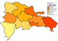
 Mapa 2-regiones-n.JPG 794 × 570; 68 KB
-
 Mapa 3-regiones-n.JPG 794 × 570; 66 KB
-
 Mapa regiones-2.jpg 794 × 570; 97 KB
-
 Non-Haitian immigrants in the DR.png 800 × 573; 28 KB
-
 Palo Hincado map.gif 264 × 227; 3 KB
-
 People of Haitian origin in the Dominican Republic.png 800 × 573; 32 KB
-
 Regiones de desarrollo de la República Dominicana.png 4,959 × 3,509; 668 KB
.jpg)


