Category:Maps of the Battle of Leipzig
Media in category "Maps of the Battle of Leipzig"
The following 34 files are in this category, out of 34 total.
-
 563 of 'Die Hohenzollern und das Reich, etc' (11167942806).jpg 2,544 × 1,701; 1.42 MB
-
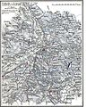
 913 of 'Napoléon et son temps ... Ouvrage illustré ... Neuvième mille' (11236525785).jpg 1,652 × 1,485; 640 KB
-
 Batailles de Leipzig, Livrées le 16, 18, 19 Octobre 1813 01.jpg 4,177 × 3,777; 4.26 MB
-
 Batailles de Leipzig, Livrées le 16, 18, 19 Octobre 1813 02.jpg 4,108 × 3,689; 3.64 MB
-
 Bielefeld Huelsmann Völkerschlacht1.jpg 960 × 1,280; 310 KB
-
 Bielefeld Huelsmann Völkerschlacht2.jpg 1,024 × 768; 182 KB
-
 Carte de la Bataille de Leipzig, 16 octobre 1813, de 13h jusqu'au soir.jpg 1,808 × 2,316; 868 KB
-
 Carte de la Btaille de Leipzig. 16 octobre 1813 entre 8 heures et 13 heures.jpg 1,853 × 2,296; 1.04 MB
-
 Deutschland BV042513042 (cropped).jpg 1,779 × 2,790; 800 KB
-
 Die Gartenlaube (1863) b 668.jpg 3,944 × 2,283; 2.97 MB
-
 Karte Voelkerschlacht bei Leipzig 16 Oktober 1813.png 742 × 813; 150 KB
-
 Karte Voelkerschlacht bei Leipzig 18 Oktober 1813.png 741 × 739; 134 KB
-
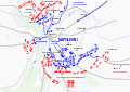
 Leipzig Battle 2 de.svg 1,052 × 744; 199 KB
-
 Leipzig Battle 2-hu.svg 1,052 × 744; 200 KB
-
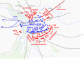 Leipzig Battle 2.svg 1,052 × 744; 164 KB
-
 Leipzig Battle de.svg 1,052 × 744; 194 KB
-
 Leipzig Battle-hu.svg 1,052 × 744; 195 KB
-
 Leipzig Battle.svg 1,052 × 744; 194 KB
-
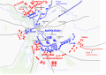
 Leipzig Voelkerschlacht 16terOktober.png 800 × 566; 269 KB
-
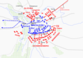 Leipzig Voelkerschlacht 18terOktober.png 800 × 566; 258 KB
-
 Map Leipzig 16 Oktober 1813 rus color.png 742 × 813; 320 KB
-
 Map Leipzig 18 Oktober 1813 rus color.jpg 741 × 739; 420 KB
-
 Meyers b10 s0670 b1.png 750 × 825; 268 KB
-
 Meyers b10 s0671 b1.png 750 × 746; 239 KB
-
 Plan der Schlacht bei Leipzig am 18. und 19. Oktober 1813.jpg 2,791 × 2,464; 2.12 MB
-
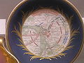
 Plan der Völkerschlacht auf Untertasse KGM Hz517.jpg 2,250 × 2,258; 3.36 MB
-
 Schlacht bei Leipzig.jpg 5,667 × 6,906; 7.59 MB
-
 Schotel met strategische kaart van slag bij Leipzig, BK-NM-13875-A.jpg 6,065 × 6,065; 3.23 MB
-

-
 Alison's history of Europe atlas 1850 (92104696).jpg 6,997 × 5,803; 5.8 MB
-
 Atlas der Schlachten, Treffen und Belagerungen 1857 (92445144).jpg 3,243 × 4,622; 3.44 MB
-

-

-
 Карта к статье «Лейпциг» № 2. Военная энциклопедия Сытина (Санкт-Петербург, 1911-1915).jpg 2,072 × 2,380; 1.04 MB
.jpg)
.jpg)


.jpg)
_b_668.jpg)


.jpg)
.jpg)
.jpg)
.jpg)
.jpg)