Category:Maps of the Byzantine Empire in 565
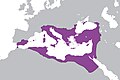
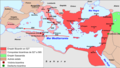
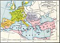
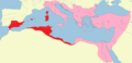
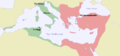
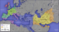
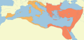
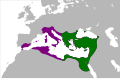
This category contains maps depicting the Byzantine Empire at its greatest extent during Late Antiquity, at the death of Emperor Justinian I in 565 AD.
Media in category "Maps of the Byzantine Empire in 565"
The following 47 files are in this category, out of 47 total.
-
 4KJUSTINIAN.png 3,840 × 2,160; 524 KB
-
 565 CE, Europe.svg 512 × 438; 1.5 MB
-
 Area at the time of Justinian I's death in the Byzantine Empire.png 2,500 × 1,431; 519 KB
-
 BizancjumVI.png 733 × 362; 46 KB
-
 Bizánc550.PNG 800 × 370; 29 KB
-
 Bysantin valtakunta keisari Justinianuksen aikana.png 800 × 370; 24 KB
-
 Byzanc za Justiniána.png 893 × 506; 263 KB
-
 Byzanc-Justinián.png 2,000 × 1,100; 2.38 MB
-
 ByzantEmpLang VI s-IT.jpg 500 × 419; 66 KB
-
 ByzantEmpLang VI s.jpg 432 × 362; 56 KB
-
 Byzantime Empire around 565 AD.svg 2,080 × 1,100; 89 KB
-
 Byzantine Empire.PNG 280 × 200; 11 KB
-
 Byzantine Empire.png 500 × 231; 14 KB
-
 Byzantine mints of Justinian I.png 1,176 × 538; 82 KB
-
 Byzantine Spain - 565-586ru.svg 798 × 444; 293 KB
-
 ByzantineEmpireGE.PNG 1,084 × 705; 33 KB
-
 Byzantinemax.png 800 × 370; 29 KB
-
 Eastern Roman Empire 565 AD.png 800 × 385; 101 KB
-
 Eastern Roman Empire, Justinian the Great period(AD550).jpg 2,100 × 1,392; 178 KB
-
 EasternRomanEmpire.png 250 × 175; 7 KB
-
 Empèri Bizantin - Periòde de Justinian 2.png 1,018 × 574; 250 KB
-
 Empèri Bizantin - Rèine de Justinian.png 1,018 × 574; 250 KB
-
 España bizantina 5-fr.svg 798 × 444; 299 KB
-
 España bizantina 5-hu.svg 3,731 × 2,000; 527 KB
-
 España bizantina 5.svg 3,731 × 2,000; 917 KB
-
 España bizantina-pt.svg 512 × 274; 142 KB
-
 Europe at the death of Justinian I in 565.jpg 2,747 × 1,966; 4.19 MB
-
 Europe-In-555AD.png 2,862 × 1,670; 2.85 MB
-
 Exarchate of Africa.png 800 × 378; 15 KB
-
 Exarchate-Africa.png 1,810 × 871; 256 KB
-
 Exarchate-Ravenna.png 1,810 × 871; 256 KB
-
 Expansion del Imperio Bizantino.jpg 2,432 × 1,873; 531 KB
-
 ImperiBizantí550.png 800 × 370; 23 KB
-
 Justinian Byzanz-BLANCO.png 2,000 × 1,100; 685 KB
-
 Justinian Byzanz.png 2,000 × 1,100; 1.96 MB
-
 Justinian550AD.png 694 × 396; 13 KB
-
 Justinien 527-565.svg 1,810 × 871; 577 KB
-
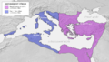
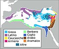
 Lingue impero bizantino 565.JPG 906 × 409; 86 KB
-
 LocationByzantineEmpire.png 1,084 × 705; 29 KB
-
 LocationByzantineEmpire.svg 1,084 × 705; 181 KB
-
 Major powers in Eurasia around 555AD.png 19,000 × 9,439; 8.64 MB
-
 NE 565ad.jpg 1,477 × 973; 226 KB
-
 Roman-Empire 565ad.jpg 1,287 × 875; 1.23 MB
-
 Spruner-Menke Handatlas 1880 Karte 02.jpg 10,385 × 8,785; 17.91 MB
-
 The Byzantine State under Justinian I-es.svg 1,873 × 935; 713 KB
-
 The Byzantine State under Justinian I-pt.svg 1,873 × 935; 671 KB
-
 The Byzantine State under Justinian I-sr.svg 1,810 × 871; 806 KB


.jpg)


