Category:Maps of the Don Cossacks
Media in category "Maps of the Don Cossacks"
The following 11 files are in this category, out of 11 total.
-
 100-sheets Map of the Russian Empire 1804-1816 (S 054) — Archeda river.jpg 1,322 × 819; 343 KB
-
 1833. Detailed map of the Don Cossack Host.jpg 15,404 × 15,287; 21.84 MB
-

-

-

-
 Detailed map of the Don Cossack Host (1833) — Archeda.jpg 2,958 × 1,729; 3.61 MB
-
 Don-Gebiet BV044705450.jpg 8,260 × 8,923; 8.18 MB
-
 Lowry, J.W.; Sharpe, J. Russia at the Caucasus. 1847 (I).jpg 1,096 × 1,028; 294 KB
-
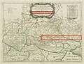 Map of Ukraine, or Country of the Cossack, by Sanson, Nicolas (1600-1667) Cartographe.jpg 2,678 × 2,048; 3.16 MB
-
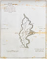 Part of the Island and Town of Tscherchaskoy - Clarke Edward Daniel - 1810.jpg 1,205 × 1,500; 437 KB
-
 Черкаський округ.jpg 1,709 × 3,029; 576 KB
_%E2%80%94_Archeda_river.jpg)

_(With_plates,_including_a_portrait.))%27_(11003419884).jpg)
.jpg)
.jpg)
_%E2%80%94_Archeda.jpg)

.jpg)
_Cartographe.jpg)

