Category:Maps of the Great Wall of China
Wikimedia list article | |||||
| Upload media | |||||
| Instance of | |||||
|---|---|---|---|---|---|
| |||||
Subcategories
This category has the following 6 subcategories, out of 6 total.
H
- Huayitu (13 F)
L
- La Chine Royaume (4 F)
Media in category "Maps of the Great Wall of China"
The following 200 files are in this category, out of 208 total.
(previous page) (next page)-
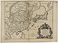
 "Pecheli, sive Peking, imperii Sinarum provincia prima." (22263939511).jpg 3,615 × 3,020; 1.9 MB
-
 "Xansi, Imperii Sinarum provincia Secunda." (22227329376).jpg 3,625 × 3,026; 2.22 MB
-
 "Xantung, Sinarum Imperii provincia quarta." (21632336863).jpg 3,691 × 3,025; 2.09 MB
-
 "Xensi, Imperii Sinarum provincia Tertia. " (22240618482).jpg 3,656 × 3,036; 2.45 MB
-
 Da Ming yu di tu LOC 2002626776-2.jpg 9,794 × 9,059; 12.97 MB
-
 Da Ming yu di tu LOC 2002626776-2.tif 9,794 × 9,059; 253.84 MB
-
 Guang yu tu - er juan LOC 2008623187-1.jpg 4,380 × 4,658; 4.68 MB
-
 Guang yu tu - er juan LOC 2008623187-1.tif 4,380 × 4,658; 58.37 MB
-
 Guang yu tu - er juan LOC 2008623187-12.jpg 4,360 × 4,658; 4.31 MB
-
 Guang yu tu - er juan LOC 2008623187-12.tif 4,360 × 4,658; 58.1 MB
-
 Guang yu tu - er juan LOC 2008623187-14.jpg 4,340 × 4,658; 4.13 MB
-
 Guang yu tu - er juan LOC 2008623187-14.tif 4,340 × 4,658; 57.84 MB
-
 Guang yu tu - er juan LOC 2008623187-16.jpg 4,340 × 4,658; 4.12 MB
-
 Guang yu tu - er juan LOC 2008623187-16.tif 4,340 × 4,658; 57.84 MB
-
 Guang yu tu - er juan LOC 2008623187-19.jpg 4,340 × 4,658; 4.39 MB
-
 Guang yu tu - er juan LOC 2008623187-19.tif 4,340 × 4,658; 57.84 MB
-
 Guang yu tu - er juan LOC 2008623187-2.jpg 4,380 × 4,658; 4.55 MB
-
 Guang yu tu - er juan LOC 2008623187-2.tif 4,380 × 4,658; 58.37 MB
-
 Fen ye yu tu. LOC 2002626777-12.jpg 4,272 × 5,104; 1.81 MB
-
 Fen ye yu tu. LOC 2002626777-12.tif 4,272 × 5,104; 62.38 MB
-
 Fen ye yu tu. LOC 2002626777-21.jpg 4,217 × 5,027; 2.01 MB
-
 Fen ye yu tu. LOC 2002626777-21.tif 4,217 × 5,027; 60.65 MB
-
 Fen ye yu tu. LOC 2002626777-5.jpg 4,185 × 5,064; 2.26 MB
-
 Fen ye yu tu. LOC 2002626777-5.tif 4,185 × 5,064; 60.63 MB
-
 Fen ye yu tu. LOC 2002626777-6.jpg 4,248 × 5,118; 2.01 MB
-
 Fen ye yu tu. LOC 2002626777-6.tif 4,248 × 5,118; 62.2 MB
-
 Fen ye yu tu. LOC 2002626777-8.jpg 4,272 × 5,105; 1.88 MB
-
 Fen ye yu tu. LOC 2002626777-8.tif 4,272 × 5,105; 62.4 MB
-
 The Kingdome of China newly augmented by I.S. 1626.jpg 12,701 × 9,978; 29.59 MB
-
 AMH-6721-KB Map of China and Korea.jpg 2,400 × 2,187; 1,001 KB
-

-
-
-
 Xensi… - Atlas Maior, vol 11, map 15 - Joan Blaeu, 1667 - BL 114.h(star).11.(15).jpg 4,000 × 3,428; 2.17 MB
-
 Xantvng - Atlas Maior, vol 11, map 16 - Joan Blaeu, 1667 - BL 114.h(star).11.(16).jpg 4,000 × 3,428; 1.94 MB
-
-
 CEM-36-Regno-della-China-2355.jpg 2,421 × 1,904; 1.98 MB
-
 Chunha daechong il ram jido early 1700.jpg 800 × 665; 145 KB
-
 Delisle Asie3.png 874 × 890; 1.91 MB
-
 Delisle Asie3b.png 874 × 890; 204 KB
-
 AMH-6662-KB Map of China.jpg 1,940 × 2,400; 1.06 MB
-
 Carte des Indes et de la Chine par Guillaume de l'Isle - 1705.png 1,086 × 1,021; 2 MB
-
 Der Jesuiten-Atlas der Kanghsi-Zeit - China und die Aussenlaender LOC 74650033-10.jpg 12,177 × 9,408; 9.87 MB
-
 Der Jesuiten-Atlas der Kanghsi-Zeit - China und die Aussenlaender LOC 74650033-10.tif 12,177 × 9,408; 327.76 MB
-
 Der Jesuiten-Atlas der Kanghsi-Zeit - China und die Aussenlaender LOC 74650033-16.jpg 6,288 × 6,072; 3.87 MB
-
 Der Jesuiten-Atlas der Kanghsi-Zeit - China und die Aussenlaender LOC 74650033-16.tif 6,288 × 6,072; 109.24 MB
-
 Der Jesuiten-Atlas der Kanghsi-Zeit - China und die Aussenlaender LOC 74650033-19.jpg 11,908 × 10,548; 12.01 MB
-
 Der Jesuiten-Atlas der Kanghsi-Zeit - China und die Aussenlaender LOC 74650033-21.jpg 5,352 × 7,031; 4.22 MB
-
 Der Jesuiten-Atlas der Kanghsi-Zeit - China und die Aussenlaender LOC 74650033-23.jpg 4,810 × 6,866; 4.29 MB
-
 Der Jesuiten-Atlas der Kanghsi-Zeit - China und die Aussenlaender LOC 74650033-23.tif 4,810 × 6,866; 94.49 MB
-
 Der Jesuiten-Atlas der Kanghsi-Zeit - China und die Aussenlaender LOC 74650033-24.jpg 9,617 × 8,449; 10.06 MB
-
 Der Jesuiten-Atlas der Kanghsi-Zeit - China und die Aussenlaender LOC 74650033-24.tif 9,617 × 8,449; 232.47 MB
-
 Der Jesuiten-Atlas der Kanghsi-Zeit - China und die Aussenlaender LOC 74650033-6.jpg 8,309 × 5,884; 5.66 MB
-
 Der Jesuiten-Atlas der Kanghsi-Zeit - China und die Aussenlaender LOC 74650033-6.tif 8,309 × 5,884; 139.88 MB
-
 Der Jesuiten-Atlas der Kanghsi-Zeit - China und die Aussenlaender LOC 74650033-8.jpg 7,114 × 8,854; 6.89 MB
-
 Der Jesuiten-Atlas der Kanghsi-Zeit - China und die Aussenlaender LOC 74650033-8.tif 7,114 × 8,854; 180.21 MB
-
 Der Jesuiten-Atlas der Kanghsi-Zeit - China und die Aussenlaender LOC 74650033-9.jpg 9,514 × 9,444; 8.89 MB
-
 Der Jesuiten-Atlas der Kanghsi-Zeit - China und die Aussenlaender LOC 74650033-9.tif 9,514 × 9,444; 257.06 MB
-
 Carte des Indes et de la Chine.png 4,790 × 4,623; 31.33 MB
-

-

-
-
 Anville Nouvel atlas de la Chine - Page62 tartarie 3 ortous.jpg 4,196 × 2,596; 3.16 MB
-
 Anville Nouvel atlas de la Chine - Page95 - thibet 4e feuille ho ho nor.jpg 4,214 × 2,568; 3.79 MB
-

-
 Cartes particulières de la Tartarie chinoise - D'Anville - btv1b5963110z (03 of 12).jpg 5,840 × 3,872; 3.55 MB
-
 Cartes particulières de la Tartarie chinoise - D'Anville - btv1b5963111c (03 of 12).jpg 5,784 × 3,760; 3.73 MB
-

-

-
 1740 map of China, published by Homann Heirs.jpg 12,726 × 14,291; 45.99 MB
-
 Ca. 1740 map of China, published by Homann Heirs.jpg 12,577 × 14,235; 40.47 MB
-
 Ca. 1740 map of China, published by Homannsche Erben.jpg 12,863 × 14,455; 32.53 MB
-
 AMH-8182-KB Map of China.jpg 2,400 × 2,104; 1.37 MB
-

-

-
 L'Empire de la Chine pour servir a L'histoire générale des voyages LOC 2006629393.jpg 6,810 × 5,064; 6.37 MB
-
 L'Empire de la Chine pour servir a L'histoire générale des voyages LOC 2006629393.tif 6,810 × 5,064; 98.67 MB
-
-
 AMH-7966-KB Map of China and Korea.jpg 2,400 × 2,241; 1.29 MB
-

-

-

-
-
 KKR-20 La CHINE avec la Korée et les Parties de la Tartarie.jpg 3,148 × 2,584; 1.1 MB
-
 Tatariae Sinensis mappa geographica 1749 24374665.jpg 13,080 × 7,036; 22.5 MB
-

-
 Huang chao zhi sheng yu di quan tu - Lu ying sheng - btv1b52505943g.jpg 16,210 × 9,584; 23.59 MB
-
 Map of Korea.jpg 800 × 600; 131 KB
-
 Da Qing fen sheng yu tu LOC 2002626726-1.jpg 5,280 × 4,534; 2.43 MB
-
 Da Qing fen sheng yu tu LOC 2002626726-1.tif 5,280 × 4,534; 68.49 MB
-
 Da Qing fen sheng yu tu LOC 2002626726-2.jpg 5,269 × 4,534; 2.34 MB
-
 Da Qing fen sheng yu tu LOC 2002626726-2.tif 5,269 × 4,534; 68.35 MB
-
 L'Asie divisée en tous ses Etats 2.jpg 1,089 × 1,515; 376 KB
-
 Great Wall of China in Picaud 1763 Eurasia map.jpg 2,482 × 1,284; 548 KB
-
 1766 map - Carte de Tartarie dressee sur les relations.jpg 15,735 × 12,102; 42.68 MB
-
 A new & accurate map of China LOC 2006629424.jpg 7,154 × 5,799; 7.9 MB
-
 A new & accurate map of China LOC 2006629424.tif 7,154 × 5,799; 118.69 MB
-
 1770 Bonne Map of China, Korea, Japan and Formosa - Geographicus - China-bonne-1770.jpg 4,000 × 2,787; 3.09 MB
-

-

-
 1779 - Carte de l' Empire de la Chine avec la Tartarie Chinoise.jpg 7,144 × 5,918; 6.63 MB
-

-
 L'Empire de la Chine avec la Tartarie chinoise ; d'après l'atlas chinois. LOC 2006635530.jpg 11,680 × 8,183; 13.84 MB
-
 L'Empire de la Chine avec la Tartarie chinoise ; d'après l'atlas chinois. LOC 2006635530.tif 11,680 × 8,183; 273.45 MB
-
 China, divided into its great provinces, and the Isles of Japan (NYPL b13919861-5207423).jpg 8,045 × 6,648; 44.32 MB
-

-
-
 1784 D'Anville Wall Map of Asia - Geographicus - Asia-anville-1794.jpg 7,000 × 6,074; 11.94 MB
-
 China divided into provinces drawn from the best authorities LOC 2006629368.jpg 8,561 × 6,705; 11.12 MB
-
 China divided into provinces drawn from the best authorities LOC 2006629368.tif 8,561 × 6,705; 164.23 MB
-
 1806 Cary Map of Tartary or Central Asia - Geographicus - Tartary-cary-1806.jpg 5,000 × 4,569; 8.57 MB
-
 Zhi li ge sheng yu di quan tu - Zhang Zongjing - btv1b53103898v (17 of 69).jpg 5,102 × 4,405; 2.65 MB
-
 Zhi li ge sheng yu di quan tu - Zhang Zongjing - btv1b53103898v (21 of 69).jpg 5,141 × 4,403; 2.54 MB
-
 Zhi li ge sheng yu di quan tu - Zhang Zongjing - btv1b53103898v (44 of 69).jpg 5,085 × 4,415; 2.46 MB
-
 Zhi li ge sheng yu di quan tu - Zhang Zongjing - btv1b53103898v (45 of 69).jpg 5,120 × 4,371; 2.41 MB
-
 Zhi li ge sheng yu di quan tu - Zhang Zongjing - btv1b53103898v (48 of 69).jpg 5,083 × 4,423; 2.85 MB
-
 Nan bei yang he tu. LOC gm71005215.jpg 5,106 × 7,122; 4.64 MB
-
 Nan bei yang he tu. LOC gm71005215.tif 5,106 × 7,122; 104.04 MB
-
 Huang chao zhi sheng di yu quan tu - btv1b531099218 (05 of 38).jpg 6,188 × 4,553; 4.05 MB
-
 Huang chao zhi sheng di yu quan tu - btv1b531099218 (19 of 38).jpg 6,236 × 4,543; 3.07 MB
-
 Tian xia zong yu tu. LOC 2002626780-1.jpg 3,847 × 3,193; 1.35 MB
-
 Tian xia zong yu tu. LOC 2002626780-1.tif 3,847 × 3,193; 35.14 MB
-
 Tian xia zong yu tu. LOC 2002626780-19.jpg 3,746 × 3,133; 928 KB
-
 Tian xia zong yu tu. LOC 2002626780-19.tif 3,746 × 3,133; 33.58 MB
-
 Tian xia zong yu tu. LOC 2002626780-2.jpg 3,761 × 3,129; 1.08 MB
-
 Tian xia zong yu tu. LOC 2002626780-2.tif 3,761 × 3,129; 33.67 MB
-
 Tian xia zong yu tu. LOC 2002626780-5.jpg 3,785 × 3,131; 1.09 MB
-
 Tian xia zong yu tu. LOC 2002626780-5.tif 3,785 × 3,131; 33.91 MB
-
 Tian xia zong yu tu. LOC 2002626780-6.jpg 3,775 × 3,138; 886 KB
-
 Tian xia zong yu tu. LOC 2002626780-7.jpg 3,778 × 3,117; 889 KB
-
 Tian xia zong yu tu. LOC 2002626780-7.tif 3,778 × 3,117; 33.69 MB
-
-
 China Postal Working Map.jpg 11,677 × 11,410; 15.67 MB
-
 AMH-5645-KB Map of China.jpg 2,400 × 1,875; 625 KB
-
 Atlas maior 1655 - vol 10 - Novus Atlas Sinensis - China - P1080382.JPG 2,560 × 1,920; 3.28 MB
-
 Atlas Van der Hagen KW1049B13 037 Xansi (Shanxi).jpg 5,500 × 4,631; 4.31 MB
-
 Atlas Van der Hagen-KW1049B13 033-IMPERII SINARVM NOVA DESCRIPTO.jpeg 5,500 × 4,292; 3.52 MB
-
 Atlas Van der Hagen-KW1049B13 034-PECHELI SIVE PEKING IMPERII SINARVM PROVINCIA PRIMA.jpeg 5,500 × 4,584; 4.32 MB
-
 Atlas Van der Hagen-KW1049B13 038-XENSI. IMPERII SINARVM PROVINCIA TERTIA.jpeg 5,500 × 4,608; 3.66 MB
-
 Atlas Van der Hagen-KW1049B13 039-XANTVNG SINARVM IMPERII PROVICIA QUARTA.jpeg 5,500 × 4,523; 3.67 MB
-

-
 Chinesische Mauer (Ortelius 1584).jpg 1,530 × 1,710; 699 KB
-
 Chinesische Mauer Karte Great Wall of China map (44042314190).jpg 10,280 × 7,719; 3.56 MB
-
 Die Chinesische Maue-HE.jpg 2,652 × 2,133; 766 KB
-
 Die Chinesische Mauer - blank-01.jpg 2,652 × 2,133; 1.52 MB
-
 Die Chinesische Mauer - Karte.jpg 2,652 × 2,133; 1.66 MB
-
 Great Wall of China 1805.jpg 631 × 200; 67 KB
-
 Great Wall of China location map blank.PNG 989 × 649; 403 KB
-
 Great Wall of China location map HE.png 989 × 649; 404 KB
-
 Great Wall of China location map.jpg 989 × 649; 166 KB
-
 Great Wall of China location map.PNG 989 × 649; 402 KB
-
 GreatWallChina1.png 934 × 752; 41 KB
-
 GreatWallChina2.png 934 × 752; 45 KB
-
 GreatWallChina3.png 934 × 752; 47 KB
-
 GreatWallChina4.png 934 × 752; 50 KB
-
 GreatWallChinaJuo-HE.jpg 659 × 551; 40 KB
-
 GreatWallOfHanDynasty blank.png 524 × 227; 238 KB
-
 GreatWallOfHanDynasty HE.png 524 × 227; 248 KB
-
 GreatWallOfHanDynasty-2010-14-07.png 524 × 227; 260 KB
-
 GreatWallOfHanDynasty.png 524 × 227; 244 KB
-
 GreatWallofQinDynasty-2010-14-07.png 379 × 319; 266 KB
-
 GreatWallofQinDynasty.png 379 × 319; 248 KB
-
 Gubeikou to Jingshanling 65 del (4758352817).jpg 5,184 × 3,456; 6.79 MB
-
 Gubeikou to Jingshanling 71 (4758218121).jpg 5,184 × 3,456; 7.91 MB
-
 Han foreign relations CE 2 chinese.jpg 965 × 650; 530 KB
-
 Han foreign relations CE 2.jpg 965 × 650; 558 KB
-
 Handynastins mur 206fKr 39eKr.jpg 1,204 × 784; 523 KB
-
 Image-Die Chinesische Mauer - Karte (mit einfachen Linien).jpg 2,652 × 2,133; 1.6 MB
-
 Imperii Sinarum nova descriptio - btv1b53179352v (1 of 2).jpg 9,820 × 7,274; 8.36 MB
-
 Imperii Sinarum nova descriptio - btv1b5963029q.jpg 7,232 × 5,592; 6.17 MB
-
 Imperii Sinarum nova descriptio - btv1b84415340.jpg 10,618 × 7,800; 10.3 MB
-
 Kinesiska muren 423-1201.jpg 1,069 × 869; 503 KB
-
 Kinesiska muren Mingdynastin.jpg 1,043 × 807; 575 KB
-
 Kinesiska muren Översikt.jpg 1,250 × 1,092; 1.83 MB
-
 Le Royaume de la Chine, divisée en provinces ou sont marqué d'une - btv1b52513475b (1 of 2).jpg 9,802 × 13,250; 13.31 MB
-
 LocMap of WH GreatWall ja.png 280 × 210; 37 KB
-
 LocMap of WH GreatWall.png 286 × 176; 14 KB
-
 Map of the Great Wall of China-2010-14-07.jpg 2,652 × 2,133; 1.52 MB
-
 Map of the Great Wall of China.jpg 2,652 × 2,133; 1.6 MB
-
 Map of the Liaodong Wall.jpg 600 × 430; 93 KB
-
 Map of Tibet in 1687 from Paradigma XV Provinciarum &c (cropped).png 927 × 2,067; 3.51 MB
-
 Ming Great Wall.png 1,270 × 901; 559 KB
-
 Murar före Qindynastin tom 221fKr.jpg 892 × 690; 398 KB
-
 Niangziguanlocation.jpg 607 × 705; 50 KB
-
 Novvs atlas Sinensis. LOC 2002625249-1.jpg 7,768 × 6,126; 5.72 MB
-
 Novvs atlas Sinensis. LOC 2002625249-1.tif 7,768 × 6,126; 136.15 MB
-
 Novvs atlas Sinensis. LOC 2002625249-2.jpg 7,498 × 6,059; 5.66 MB
-
 Novvs atlas Sinensis. LOC 2002625249-2.tif 7,498 × 6,059; 129.98 MB
-
 Paradigma XV Provinciarum &c.png 2,543 × 2,700; 14.45 MB
-
 Paradigma XV Provinciarum et CLV Urbium Capitalium Sinensis Imperij.jpg 2,670 × 3,782; 1.94 MB
-
-

-
 Peking and the overland route (1917) (14597896590).jpg 2,288 × 1,488; 342 KB
-
 Portuguese map of Asia, 1630.jpg 4,000 × 2,418; 1.43 MB
-
 Qindynastins mur 215 206 fKr.jpg 887 × 685; 414 KB
-
 Relief Mongolia Wall of Genghis Khan.jpg 1,200 × 568; 256 KB
-
 Satellitenbild Nordchina und Mongolei-2.jpg 2,553 × 1,783; 4.7 MB
-
 Satellitenbild Nordchina und Mongolei.jpg 2,553 × 1,783; 2.1 MB
-
 Simatai12.jpg 2,592 × 1,944; 866 KB
-
.jpg)
.jpg)
.jpg)
.jpg)


.11.(12).jpg)
.11.(13).jpg)
.11.(14).jpg)
.11.(15).jpg)
.11.(16).jpg)


_de_la_Tartarie_chinoise_-_par_J.-B._d%27Anville_-_btv1b84686557_(2_of_6).jpg)
.jpg)
.jpg)
.jpg)
.jpg)


_(14782754404).jpg)
.jpg)


.jpg)


.jpg)


.jpg)
.jpg)
.jpg)
.jpg)
.jpg)

.jpg)
.jpg)


.jpg)


.jpg)
.jpg)


.jpg)
.jpg)


.jpg)
.jpg)


.jpg)


.png)


_-_btv1b59630415.jpg)
.jpg)
_(14597896590).jpg)


_;_exc._Ioannes_Blaeu_-_btv1b10101753b.jpg)