Category:Maps of the Gulf of Thailand
Media in category "Maps of the Gulf of Thailand"
The following 36 files are in this category, out of 36 total.
-

-
 Admiralty Chart Catalogue 1967 Page 056 Index I.jpg 8,565 × 6,901; 8.26 MB
-
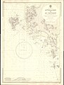
 Admiralty Chart No 2414 Gulf of Siam, Published 1855, Corrections to 1858.jpg 3,778 × 5,000; 4.43 MB
-

-
 Admiralty Chart No 3727 Approaches to Ao Sattahip, Published 1969.jpg 8,328 × 11,024; 22.31 MB
-
 Admiralty Chart No 3967 Baie de Ream to Ko Kut, Published 1957.jpg 11,103 × 16,137; 60.9 MB
-
 Bay of Bangkok mk.svg 488 × 337; 136 KB
-
 Bay of Bangkok.svg 488 × 337; 99 KB
-
 Bodleian Libraries, South China Sea and the Gulf of Siam by Joan Blaeu, 1679.jpg 672 × 1,000; 126 KB
-
 Dive Sites of Ko Tao.png 868 × 1,306; 90 KB
-
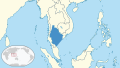 Gulf of Thailand in its region.svg 500 × 281; 4.82 MB
-
 Gulf of Thailand it.svg 488 × 479; 407 KB
-
 Gulf of Thailand ja.png 303 × 389; 7 KB
-
 Gulf of Thailand mk.svg 488 × 479; 421 KB
-
 Gulf of Thailand.png 323 × 457; 18 KB
-
 Gulf of Thailand.svg 488 × 479; 387 KB
-
 Karte Golf von Thailand es.png 446 × 515; 114 KB
-
 Karte Golf von Thailand.png 446 × 515; 675 KB
-
 Ko samui.png 446 × 515; 170 KB
-
 Koh Samui map (small).png 270 × 235; 29 KB
-
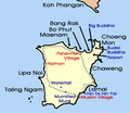
 Koh Samui map.png 300 × 320; 34 KB
-
 LocationGulfOfThailand.png 250 × 115; 3 KB
-
 Map of Mu Ko Ang Thong.jpg 399 × 952; 75 KB
-
 Mapa de Koh Tao.png 970 × 1,164; 166 KB
-
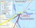 MH370 ATC and air routes map-en.svg 700 × 547; 61 KB
-
 MH370 ATC and air routes map-zh-s.svg 700 × 547; 60 KB
-
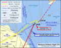 MH370 ATC and air routes map.png 4,952 × 3,864; 1.79 MB
-
 MH370 ATC-Routes map.png 4,952 × 3,864; 1.94 MB
-
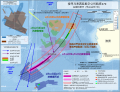
 MH370 SIO search-en.svg 4,791 × 3,673; 4.99 MB
-
 MH370 SIO search-zh-s.svg 4,791 × 3,673; 4.99 MB
-
 Mukoh angthong 256.gif 256 × 310; 31 KB
-
 Phangan Karte.png 644 × 620; 227 KB
-
 Relief map of the Malay Peninsula and Gulf of Thailand.png 482 × 413; 144 KB
-
 Samui Archipelago Transportation Map.png 648 × 624; 96 KB
-
 Thailand-Exclusive-Economic-Zone.png 432 × 288; 48 KB
-
 থাইল্যান্ড উপসাগর.svg 488 × 479; 404 KB
.jpg)


.png)


