Category:Maps of the Kingdom of Bohemia
Subcategories
This category has only the following subcategory.
Media in category "Maps of the Kingdom of Bohemia"
The following 10 files are in this category, out of 10 total.
-
 Napoleonic Central Europe.jpg 3,937 × 2,855; 2.85 MB
-
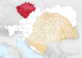
 Boehmen Donaumonarchie.png 674 × 510; 7 KB
-
 C. 1350 Bohemia.jpg 1,506 × 738; 1.39 MB
-
 Empire d'Autriche 1914 Bohême.png 3,507 × 2,480; 4.14 MB
-
 Kingdom of Bohemia in 14th Century (German).jpg 591 × 441; 128 KB
-
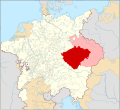 Locator Bohemia within the Holy Roman Empire (1618).svg 2,769 × 2,524; 1,021 KB
-
 Map of bohemia 1301.png 1,024 × 1,040; 287 KB
-
 Meyer‘s Zeitungsatlas 051 – Königreich Böhmen.jpg 7,413 × 6,224; 16.69 MB
-
 Osadnictwo i podboje niemieckie do 1300.gif 488 × 506; 10 KB
-
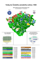 Zemské volby v Čechách 1908.svg 794 × 1,123; 379 KB


.jpg)
.svg)


