Category:Maps of the Kingdom of Holland
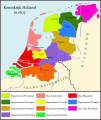
Maps of the Kingdom of Holland (Dutch: Koninkrijk Holland), a satellite state of the French First Empire from 1806 until 1810, when the French First Empire annexed it. The Kingdom of Holland replaced the earlier Batavian Republic (1795–1806), and was ruled by Louis Napoleon Bonaparte, brother of French Emperor Napoleon Bonaparte I. East Frisia was part of the Kingdom of Holland from 1807 to 1810, the only time in history this region was ever dynastically and territorially connected to the rest of the (Northern) Netherlands. It is also the only time in history when the name 'Holland' officially applied to the entire country instead of only its western coastal province(s), or merely as a pars pro toto for the entire country. On the other hand, the former Generaliteitslanden of Staats-Vlaanderen (roughly corresponding to modern Zeeuws-Vlaanderen), Staats-Overmaas and Staats-Opper-Gelre (comprising parts of the modern province of Limburg) had been annexed by France in 1795, and were also excluded from the Kingdom of Holland.
Media in category "Maps of the Kingdom of Holland"
The following 15 files are in this category, out of 15 total.
-
 1807koninkrijk holland crop.png 1,944 × 1,656; 378 KB
-
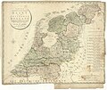 Kaart van het Koningryk Holland.jpg 9,187 × 7,723; 22.06 MB
-
 Kon-holl.jpg 486 × 421; 60 KB
-
 Map Kingdom of Holland 1807-da.svg 1,902 × 2,258; 789 KB
-
 Map Kingdom of Holland 1807-de.svg 677 × 611; 159 KB
-
 Map Kingdom of Holland 1807-el.svg 1,902 × 2,258; 930 KB
-
 Map Kingdom of Holland 1807-en.svg 1,902 × 2,258; 329 KB
-
 Map Kingdom of Holland 1807-es.svg 1,902 × 2,258; 329 KB
-
 Map Kingdom of Holland 1807-fr.svg 1,902 × 2,258; 830 KB
-
 Map Kingdom of Holland 1807-fy.svg 1,902 × 2,258; 800 KB
-
 Map Kingdom of Holland 1807-hu.svg 1,902 × 2,258; 511 KB
-
 Map Kingdom of Holland 1807-id.svg 1,902 × 2,258; 899 KB
-
 Map Kingdom of Holland 1807-lb.svg 1,902 × 2,258; 807 KB
-
 Map Kingdom of Holland 1807-nl.svg 1,902 × 2,258; 619 KB
-
 Map Kingdom of Holland 1807-tr.svg 1,902 × 2,258; 884 KB


