Category:Maps of the Marlborough Region
Regions of New Zealand: Auckland · Bay of Plenty · Canterbury · Hawke's Bay · Marlborough · Nelson · Otago · Southland · Tasman · Waikato · Wellington · West Coast
Outlying islands, territories and dependencies: Auckland Islands · Chatham Islands · Kermadec Islands · Tokelau – Territory with specific status: Ross Dependency
Associated countries: Cook Islands · Niue
Outlying islands, territories and dependencies: Auckland Islands · Chatham Islands · Kermadec Islands · Tokelau – Territory with specific status: Ross Dependency
Associated countries: Cook Islands · Niue
| NO WIKIDATA ID FOUND! Search for Maps of the Marlborough Region on Wikidata | |
| Upload media |
Media in category "Maps of the Marlborough Region"
The following 12 files are in this category, out of 12 total.
-
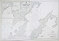 Admiralty Chart No 1096 Admiralty Bay and Current Basin, Published 1914.jpg 10,098 × 7,027; 19.77 MB
-
 Admiralty Chart No 1096 Current Basin and French Pass, Published 1857.jpg 4,306 × 5,753; 5.4 MB
-
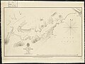 Admiralty Chart No 1414 Tory Channel, Published 1841.jpg 5,496 × 4,114; 2.78 MB
-

-
 Admiralty Chart No 2616 Cape Foulwind to D'Urville Island, Published 1858, New Edition 1913.jpg 11,890 × 8,182; 28.31 MB
-

-
 Admiralty Chart No 2684 Cook Strait Anchorages Sheet 1, Published 1859.jpg 12,741 × 8,545; 15.93 MB
-
 Admiralty Chart No 2685 Cook Strait Anchorages Sheet 2, Published 1859.jpg 7,433 × 5,092; 9.31 MB
-
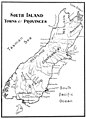 Emerald Hours in New Zealand (1906) · Lowth · 117.jpg 1,522 × 2,113; 254 KB
-
 Settlement Nelson in Suburban sections Wairau Plain & Waitoi Pass.jpg 1,080 × 1,219; 98 KB
-
 Survey Office - Grey Circuit - Tasman Bay & Golden Bay.jpg 1,080 × 1,288; 87 KB
-
 Survey Office - Wangamoa District.jpg 1,080 × 1,315; 101 KB


_%C2%B7_Lowth_%C2%B7_117.jpg)


