Category:Maps of the Mentawai Islands
Media in category "Maps of the Mentawai Islands"
The following 11 files are in this category, out of 11 total.
-

-
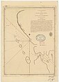 Admiralty Chart No 864 The Passage between the Islands of Great Fortune, Published 1786.jpg 2,960 × 4,146; 2.07 MB
-

-

-

-
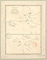 Forrest Chart Strait of Secockup, Mazular Island, Published 1782.jpg 3,288 × 4,184; 2.73 MB
-
 ID - Mentawai.png 824 × 559; 27 KB
-
 Mentawai Islands Map.png 1,360 × 1,566; 96 KB
-
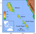 Mentawai Islands Topography.png 1,841 × 1,768; 1,017 KB
-
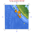
 October 2010 Sumatra Earthquake.png 757 × 741; 379 KB
-
 Sumatra 2007 earthquakes map.gif 505 × 496; 30 KB


