Category:Maps of the Missouri River
Media in category "Maps of the Missouri River"
The following 46 files are in this category, out of 46 total.
-
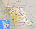 Missouririvermap.jpg 934 × 749; 665 KB
-
 Mo rivers2.png 1,000 × 1,000; 640 KB
-
 Mt-rivers.gif 1,325 × 829; 269 KB
-
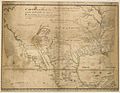 1721 Map of the new part of French Louisiana.jpg 8,104 × 6,291; 14.19 MB
-
 Nodaway-lewis.jpg 889 × 843; 140 KB
-

-

-

-
-

-
 Archives nationales d’outre-mer - Louisiane - Jacques-Nicolas Bellin - 1744 - 001.jpg 5,262 × 3,921; 3.73 MB
-
 Arikara Villages, 1823-1886, PNG file.png 1,076 × 863; 1,022 KB
-
 Carter-lake-map.png 575 × 425; 37 KB
-

-
 Hugh glass.jpg 300 × 250; 70 KB
-

-
-

-
 Karte Pick–Sloan Missouri Basin Program.png 1,892 × 1,262; 2.2 MB
-

-
 Map of Kansas and Nebraska. LOC 98688397.jpg 8,719 × 6,964; 8.28 MB
-
 Map Pick–Sloan Missouri Basin Program.png 1,892 × 1,262; 2.27 MB
-
 Missouri River basin map.png 1,496 × 1,075; 2.63 MB
-
 Missouri-flood1.jpg 409 × 255; 98 KB
-
 Missouririverecoregions.jpg 971 × 771; 366 KB
-
 Missouririvermap cut.jpg 689 × 520; 121 KB
-
 MissouriRiverStateMap.jpg 302 × 227; 52 KB
-
 Mo-river-rain1.jpg 842 × 466; 322 KB
-
-
 Ohio archæological and historical quarterly (1887) (14578061279).jpg 1,972 × 1,428; 345 KB
-
 On the geology and natural history of the upper Missouri BHL30456122.jpg 3,806 × 5,534; 2.47 MB
-
 Pais des Illinois.jpg 780 × 570; 363 KB
-
 PerrinduLac1802.png 4,779 × 3,703; 42.21 MB
-
 Pick-Sloan Plan.png 831 × 550; 54 KB
-

-
 Posssible migration routes of the Mandans to Heart River, North Dakota.png 1,753 × 1,613; 164 KB
-

-
 PSM V25 D612 Upper missouri river system.jpg 3,635 × 2,052; 506 KB
-
 PSM V25 D614 Plan of river valley.jpg 3,600 × 1,961; 1.07 MB
-
 Westport, 1842.png 962 × 1,200; 1.71 MB
-

-
 Wpdms nasa topo cannonball river.jpg 300 × 250; 45 KB
-
 Wpdms nasa topo hugh glass route.jpg 292 × 325; 14 KB
-
 Wpdms nasa topo james river south dakota.jpg 300 × 250; 45 KB
-
 Wpdms nasa topo missouri river.jpg 410 × 350; 68 KB
-


%27_(11162126253).jpg)
.jpg)
.png)


_(14591317169).jpg)


.jpg)
_(14578061279).jpg)


.png)


