Category:Maps of the Netherlands during World War II
Subcategories
This category has the following 4 subcategories, out of 4 total.
Media in category "Maps of the Netherlands during World War II"
The following 20 files are in this category, out of 20 total.
-
 Bombardement op Amsterdam-Noord (cropped).jpeg 960 × 675; 135 KB
-
 Bombardement op Amsterdam-Noord.jpeg 1,200 × 675; 178 KB
-
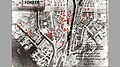
 Bombing of Bezuidenhout (1945-03-03).svg 562 × 423; 60 KB
-
 De strijd op Texel.png 811 × 1,049; 179 KB
-
 Duitse tegenaanval Oost-Betuwe.png 1,794 × 2,386; 5.73 MB
-
 Guy Fawkes 1944.png 1,536 × 861; 593 KB
-

-
 Kaart Bruggenhoofd bij Spijkenisse A233 3-5-1944.jpg 6,746 × 3,130; 7.76 MB
-
 Kaart Bruggenhoofd Spijkenisse 187 dd 23-8-1944.jpg 3,311 × 4,100; 3.68 MB
-
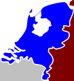 Kingdom of the Netherlands (1940).svg 31 × 34; 486 KB
-
 Netherlands-map1-en.gif 350 × 350; 22 KB
-
 Operatie Destoyer kaart.png 3,741 × 2,369; 12.62 MB
-
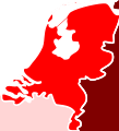
 Reichskommissariat Niederlande (1942).svg 450 × 456; 500 KB
-
 Reichskommissariat Niederlande.svg 31 × 34; 625 KB
-
 Rhineland Campaign - 11-21 March 1945.jpg 1,261 × 956; 2.05 MB
-
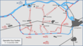
 The Nijmegen Island 2-7 December 1944.jpg 800 × 503; 136 KB
-
 Walcheren2.gif 576 × 516; 16 KB
-
 Western Front - 20 Dec 1944.jpg 1,050 × 1,186; 213 KB
-
 WWII - The War of Lines (RU).svg 756 × 800; 2.82 MB
-
 WWIIEurope68.jpg 3,706 × 2,871; 3.78 MB
.jpeg)

.svg)


.svg)


.svg)


.svg)
