Category:Maps of the North Palatine Uplands
Media in category "Maps of the North Palatine Uplands"
The following 10 files are in this category, out of 10 total.
-
 Einzugsgebietskarte Nahe.png 2,909 × 2,772; 12.73 MB
-
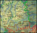
 Naturraumkarte Nordpfaelzer Bergland.png 2,272 × 1,810; 6.27 MB
-
 Naturraumkarte Donnersbergmassiv und Kaiserstrassensenke.png 1,035 × 946; 1.37 MB
-
 Naturraumkarte Glan-Alsenz-Hoehen.png 1,035 × 842; 1.3 MB
-
 Naturraumkarte Kirner Nahewinkel und Sobernheimer Talweitung.png 1,035 × 689; 1.01 MB
-

-
 Naturraumkarte Kuseler Bergland, Osterhoehen und Hoecherberg.png 1,035 × 1,018; 1.51 MB
-
 Naturraumkarte Lauterhoehen.png 1,035 × 770; 1.15 MB
-
 Naturraumkarte Porphyrbergland von Muenster am Stein und Wiesener Randhoehen.png 1,035 × 792; 1.14 MB
-
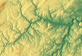 Sobernheimer Talweitung (Relief).png 1,132 × 776; 1.12 MB


.png)