Category:Maps of the Paris Metro
| Upload media | |||||
| Subclass of | |||||
|---|---|---|---|---|---|
| |||||
Subcategories
This category has the following 9 subcategories, out of 9 total.
Media in category "Maps of the Paris Metro"
The following 23 files are in this category, out of 23 total.
-
 Arsenal (Paris Metro).png 250 × 230; 27 KB
-
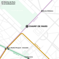
 Champ de Mars (Paris Metro).png 250 × 230; 19 KB
-
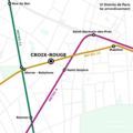
 Croix-Rouge (Paris Metro).png 300 × 276; 60 KB
-
 First-Arrondissement-Metro-.jpg 941 × 830; 163 KB
-
 Gare du Nord USFRT (Paris Metro).png 250 × 230; 58 KB
-
 Haxo (Paris Metro).png 261 × 234; 17 KB
-
 Metro Paris Novembre 1939.jpg 1,276 × 801; 777 KB
-
 Nouveau plan du Métropolitain et du Nord-Sud de Paris - btv1b530581734.jpg 5,872 × 4,592; 4.89 MB
-
 Paris Estacion fantasma Arsenal.png 1,200 × 1,200; 356 KB
-
 Paris Estacion Fantasma Champ de Mars.png 1,200 × 1,200; 260 KB
-
 Paris Estacion fantasma Croix-Rouge.png 1,200 × 1,200; 288 KB
-
 Paris Estacion fantasma Haxo.png 1,200 × 1,200; 287 KB
-
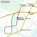 Paris Estacion fantasma Porte Molitor.png 1,200 × 1,200; 368 KB
-
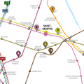
 Paris Estación fantasma Saint-Martin.png 1,200 × 1,200; 504 KB
-
 Paris. Plan du Métropolitain - btv1b530622780.jpg 10,707 × 8,269; 17.69 MB
-

-
 Plan Metro Paris 13 11 2019.svg 2,282 × 930; 185 KB
-
 Porte Molitor (Paris Metro).png 300 × 276; 43 KB
-
 Reseau de transport public du grand paris ligne bleue.svg 774 × 718; 155 KB
-
 Reseau de transport public du grand paris ligne verte.svg 745 × 600; 45 KB
-
 Reseau primaire de transport du grand paris ligne rouge.svg 575 × 358; 56 KB
-
 Reseau primaire.svg 723 × 587; 38 KB
-
 Saint-Martin (Paris Metro).png 1,187 × 1,188; 164 KB
.png)
.png)
.png)

.png)
.png)


.jpg)
.png)

.png)