Category:Maps of the Sassanid Empire in the 5th century
Media in category "Maps of the Sassanid Empire in the 5th century"
The following 9 files are in this category, out of 9 total.
-
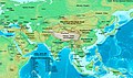 Asia 500ad.jpg 2,196 × 1,305; 435 KB
-
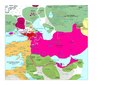 Moyen-Orient en 450.pdf 1,752 × 1,239; 430 KB
-
 Onoguria Sasanian Map.png 1,199 × 742; 75 KB
-
 Roman-Empire 477ad-es.svg 512 × 287; 36 KB
-
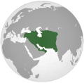
 Roman-Persian Frontier, 5th century-es.svg 1,500 × 1,350; 1.59 MB
-
 Roman-Persian Frontier, 5th century-pt.svg 1,500 × 1,350; 92 KB
-
 Roman-Persian Frontier, 5th century-zh.svg 1,875 × 1,687; 365 KB
-
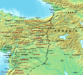 Roman-Persian Frontier, 5th century.png 857 × 769; 903 KB
-
 公元500年的萨珊王朝.svg 1,000 × 980; 792 KB


