Category:Maps of the Taiwan Strait
Media in category "Maps of the Taiwan Strait"
The following 20 files are in this category, out of 20 total.
-
-
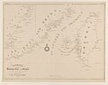
 Admiralty Chart No 1760 The Brothers to Ockseu Island, Published 1891.jpg 20,790 × 11,294; 67.52 MB
-

-
 Admiralty Chart No 1957 Hao-Wang Chiao to Hsiung-Ti Tao, Published 1934, New Edition 1954.jpg 16,381 × 11,301; 45.62 MB
-
 Admiralty Chart No 1959 Wei-T'ou Ao and Shen-Hu Wan, Published 1849, Large Corrections 1954.jpg 8,247 × 11,259; 17.84 MB
-
 Admiralty Chart No 1968 Tai-Wan and Strait, Published 1966.jpg 16,365 × 11,235; 36.98 MB
-
 Admiralty Chart No 1985 Hai-T'an Hsia, Published 1959.jpg 11,068 × 16,307; 53.55 MB
-

-
 Bathymetry and ocean currents of the Taiwan Strait and nearby areas.png 1,205 × 1,218; 687 KB
-
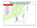 Flight paths of PLA aircraft, October 4, 2021.pdf 1,650 × 1,275; 65 KB
-
 Kaart van de Chineesche kust en van Formosa 1849.jpg 6,252 × 4,906; 2.21 MB
-
 Landform of Kinmen and Matsu.png 1,108 × 636; 66 KB
-
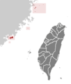 ROC Fuchien.png 362 × 425; 11 KB
-
 Surface-to-Air Missile Coverage over the Taiwan Strait-ar.png 596 × 599; 185 KB
-
 Surface-to-Air Missile Coverage over the Taiwan Strait.png 738 × 753; 104 KB
-
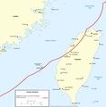
 Taiwan Strait Tunnel Project.png 957 × 585; 281 KB
-
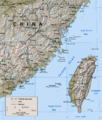 Taiwan Strait.png 681 × 800; 207 KB
-
 TaixinanPendi.JPG 540 × 276; 29 KB
-
 台湾淺灘.png 1,309 × 873; 234 KB
-
 民國109年9月19日共軍侵犯中華民國防空識別區以及越過台海中線.png 1,218 × 897; 394 KB


