Category:Maps of the United Provinces of the Río de la Plata
Media in category "Maps of the United Provinces of the Río de la Plata"
The following 29 files are in this category, out of 29 total.
-

-
 Amérique du sud 1821.jpg 400 × 442; 90 KB
-
 Amérique du sud en 1821-fr.svg 3,527 × 3,897; 114 KB
-
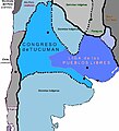
 Liga de los Pueblos Libres - en - League of the Free Peoples.png 520 × 1,004; 26 KB
-
 Liga Federal -1815.jpg 286 × 532; 33 KB
-
 Liga Federal -1815.png 286 × 532; 50 KB
-
 Liga federal.jpg 400 × 441; 127 KB
-
 Liga federal.svg 1,187 × 1,543; 983 KB
-
 Mapa ARGENTINA 1816.jpg 400 × 441; 87 KB
-
 Mapa ARGENTINA 1816.svg 1,266 × 1,645; 634 KB
-
 Mapa ARGENTINA 1821.jpg 400 × 442; 108 KB
-
 Mapa ARGENTINA 1821.svg 1,266 × 1,645; 637 KB
-
 Mapa ARGENTINA1815 ligafederal.jpg 400 × 441; 65 KB
-
 Mapa de argentina en 1816.svg 1,003 × 1,297; 408 KB
-
 Mapa de la isla Soledad hecho por Vernet.jpg 3,732 × 4,401; 4.15 MB
-
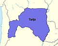
 Mapa de Tarija (1772-1826).png 571 × 636; 56 KB
-
 Mapa provincias unidas 1823.jpg 400 × 442; 28 KB
-
 Mapa rio de la plata 1816.jpg 400 × 441; 89 KB
-
 MAPAprovincias unidas de sudamerica.png 244 × 416; 38 KB
-
 Plan de las Islas Malvinas o Falkland, 1841.jpg 2,799 × 1,721; 930 KB
-
 Prov. Unidas.png 764 × 1,206; 46 KB
-
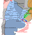
 Provincias Unidas 1821.png 400 × 442; 97 KB
-
 Provincias Unidas de Sud América -1816.png 286 × 532; 49 KB
-
 Provincias unidas de sudamerica.png 244 × 416; 39 KB
-
 Provincias Unidas.png 764 × 1,206; 19 KB
-
 ProvinciasUnidas1812 01.png 399 × 437; 98 KB
-
 Tarija.png 250 × 202; 27 KB
-
 Territorio de Tarija (1772-1826).jpg 1,321 × 1,052; 70 KB
-
 United Provinces (2675753802).jpg 1,571 × 2,000; 2.62 MB
_-_Geographicus_-_LaPlata-pinkerton-1818.jpg)


.png)


.jpg)
.jpg)