Category:Maps of the Waverley Route
Media in category "Maps of the Waverley Route"
The following 23 files are in this category, out of 23 total.
-
 Borders Railway en.png 2,234 × 2,362; 3.08 MB
-
 Britische Hauptlinien Eisenbahn-Diagramm Waverley Line.png 698 × 933; 303 KB
-
 Ordnance Survey Sheet NT 35 Moorfoot Hils, Published 1955.jpg 7,180 × 7,661; 4.78 MB
-
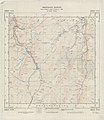
 Ordnance Survey Sheet NT 36 (36 36) Dalkeith, Published 1947.jpg 7,575 × 9,720; 14.17 MB
-
 Ordnance Survey Sheet NT 37 Musselburgh, Published 1955.jpg 7,596 × 8,771; 15.13 MB
-
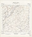
 Ordnance Survey Sheet NT 43 (36 43) Galashiels, Published 1950.jpg 7,111 × 7,723; 5.62 MB
-
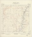
 Ordnance Survey Sheet NT 44 (36 44) Stow, Published 1950.jpg 7,160 × 7,711; 4.89 MB
-
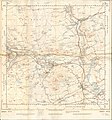
 Ordnance Survey Sheet NT 45 (36 45) Soutra, Published 1950.jpg 7,481 × 8,792; 5.18 MB
-
 Ordnance Survey Sheet NT 50 Shankend, Published 1954.jpg 7,604 × 8,751; 13.49 MB
-
 Ordnance Survey Sheet NT 51 Hawick, Published 1954.jpg 7,372 × 7,519; 9.02 MB
-
 Ordnance Survey Sheet NT 52 (36 52), Published 1950.jpg 7,628 × 8,792; 12.28 MB
-
 Ordnance Survey Sheet NT 53 (36 53) Melrose. Published 1950.jpg 7,612 × 8,771; 12.74 MB
-
 Ordnance Survey Sheet NT 53 Melrose, Published 1954 2.jpg 7,163 × 7,695; 5.19 MB
-
 Ordnance Survey Sheet NY 35 (35 35) Carlisle (west), Published 1948.jpg 7,640 × 8,898; 11.61 MB
-
 Ordnance Survey Sheet NY 36 (35 36) Longtown, Published 1948.jpg 7,700 × 9,830; 12.61 MB
-
 Ordnance Survey Sheet NY 47 (35 47) Rowanburn, Published 1950.jpg 7,668 × 8,869; 12.15 MB
-
 Ordnance Survey Sheet NY 48 (35 48) Newcastleton, Published 1950.jpg 7,680 × 8,876; 12.49 MB
-
 Waverley Line 1969 en.png 2,234 × 5,153; 6.04 MB
-
 Waverley Line 1969.png 2,234 × 5,153; 6.02 MB
-
 Waverley Line 2015 en.png 2,234 × 2,362; 3.02 MB
-
 Waverley Line 2015.png 2,234 × 2,362; 3.04 MB
-
 Waverley Line Hawick Detail.png 564 × 701; 796 KB
-
 Waverley Line.png 2,438 × 1,993; 3.08 MB


_Dalkeith,_Published_1947.jpg)

_Galashiels,_Published_1950.jpg)
_Stow,_Published_1950.jpg)
_Soutra,_Published_1950.jpg)


,_Published_1950.jpg)
_Melrose._Published_1950.jpg)

_Carlisle_(west),_Published_1948.jpg)
_Longtown,_Published_1948.jpg)
_Rowanburn,_Published_1950.jpg)
_Newcastleton,_Published_1950.jpg)


