Category:Maps of the districts of Petersberg (Saalekreis)
Media in category "Maps of the districts of Petersberg (Saalekreis)"
The following 13 files are in this category, out of 13 total.
-
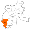
 Brachstedt in Petersberg (Saalekreis).svg 468 × 439; 85 KB
-
 Districts of the municipality Petersberg (Saalekreis).svg 468 × 439; 86 KB
-
 Gutenberg in Petersberg (Saalekreis).svg 468 × 439; 84 KB
-
 Krosigk in Petersberg (Saalekreis).svg 468 × 439; 85 KB
-
 Kütten in Petersberg (Saalekreis).svg 468 × 439; 85 KB
-
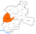
 Morl in Petersberg (Saalekreis).svg 468 × 439; 85 KB
-
 Mösthinsdorf in Petersberg (Saalekreis).svg 468 × 439; 85 KB
-
 Nehlitz in Petersberg (Saalekreis).svg 468 × 439; 85 KB
-
 Ostrau in Petersberg (Saalekreis).svg 468 × 439; 85 KB
-
 Petersberg in Petersberg (Saalekreis).svg 468 × 439; 85 KB
-
 Sennewitz in Petersberg (Saalekreis).svg 468 × 439; 85 KB
-
 Teicha in Petersberg (Saalekreis).svg 468 × 439; 85 KB
-
 Wallwitz in Petersberg (Saalekreis).svg 468 × 439; 85 KB
.svg)
.svg)
.svg)
.svg)
.svg)
.svg)
.svg)
.svg)
.svg)
.svg)
.svg)
.svg)
.svg)