Category:Maps of the history of Brabant
Media in category "Maps of the history of Brabant"
The following 29 files are in this category, out of 29 total.
-

-
 Gelre1477.png 772 × 673; 937 KB
-
 Brabant in the world.png 742 × 838; 60 KB
-
 Brabant map.png 402 × 599; 30 KB
-
 Brabant primitif.jpg 744 × 442; 64 KB
-
 Brabant1477.png 409 × 362; 331 KB
-
 County of Hoorne.png 332 × 318; 214 KB
-
 County of Soissons (1180).png 427 × 398; 107 KB
-
 Duchy of Brabant and Duchy of Guelders (1350) locator map.svg 2,813 × 3,602; 384 KB
-
 Eersel 10046. At-mF (84x60 6 MB) 2023-06-03.jpg 4,763 × 3,402; 5.75 MB
-
 Eersel 10046. At-mF 420x300 27,7 MB) 2023-06-07.jpg 11,907 × 8,505; 26.42 MB
-
 Grafschaft Hennegau 1250.PNG 745 × 479; 265 KB
-
 Kaartbrabant.jpg 380 × 400; 31 KB
-
 Locator Duchy of Brabant (1350).svg 2,818 × 3,608; 427 KB
-
 Locator Duchy of Brabant and Limburg (1350).svg 2,818 × 3,608; 427 KB
-
 Low Countries Locator Brabant Limburg and Overmaas.svg 1,550 × 2,000; 212 KB
-
 Low Countries Locator Brabant.svg 1,550 × 2,000; 381 KB
-
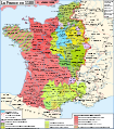
 Map France 1180-br.svg 988 × 1,124; 1.9 MB
-
 Map France 1180-de.svg 988 × 1,124; 1.94 MB
-
 Map France 1180-es.svg 988 × 1,124; 1.97 MB
-
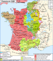
 Map France 1180-fr.svg 988 × 1,124; 1.88 MB
-
 Map France 1180-ru.svg 988 × 1,124; 1.88 MB
-
 Map France 1180-uk.svg 988 × 1,124; 1.68 MB
-
 VGhK.014N F1-F5 Witreit-Weibosch, Postelse Heide 16,2 MB 2023-10-23.jpg 6,804 × 9,526; 15.4 MB
-
 VGhK.014N Witreit-Weibosch 19,6 MB 2023-10-23.jpg 9,526 × 6,804; 18.71 MB
-
 VGhK.F1-F2 Bergeijk Witreit Weebosch (50-75 23,4MB 2023-11-19)jpg.jpg 9,668 × 6,906; 22.3 MB
-
 VGK.014N F1-F5 Witreit-Weibosch, Postelse Heide 16,8 MB 2023-10-23.jpg 6,804 × 9,526; 16.03 MB
-
 VGK.014N Witreit-Weibosch 20,8 MB 2023-10-23.jpg 9,526 × 6,804; 19.82 MB
-
 War of the Brabantian Succession (1355–1357) locator map.svg 2,813 × 3,602; 388 KB


.png)
_locator_map.svg)
_2023-06-03.jpg)
_2023-06-07.jpg)


.svg)
.svg)


jpg.jpg)


_locator_map.svg)